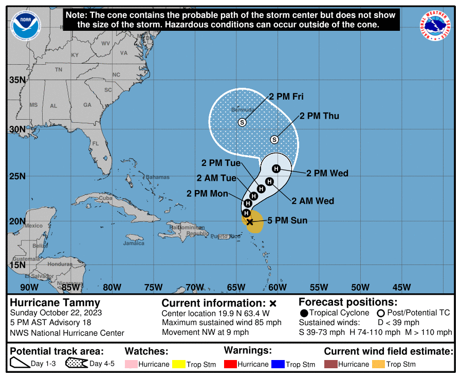
The forecast track for Hurricane Tammy produced by the National Hurricane Center has radically changed; rather than curve out to sea and not be a threat to land beyond the Northern Leeward Islands, the new track curves the storm to the west, possibly threatening Bermuda and beyond.
Right now, according to the latest advisory from the Miami, Florida-based National Hurricane Center (NHC), the center of Tammy was located about 120 miles north of Anguilla. The hurricane had maximum sustained winds of 85 mph. Tammy is moving slowly to the northwest at 9 mph; the estimated minimum central pressure is down to 988 mb or 29.18″.
With the storm moving away from the Leeward Islands, all hurricane and tropical storm watches and warnings have been dropped.
While Tammy is moving to the northwest for now, the NHC expects the storm to take on a turn toward the north late tonight, followed by a north-northeast or northeast motion on Monday and Tuesday. Beyond then, though, the NHC forecast curves the storm path back towards the U.S. East Coast, possibly impacting Bermuda by the end of the week.
Maximum sustained winds are near 85 mph with higher gusts now; the NHC says some slight strengthening is possible during the next few days. However, as the storm moves over cooler waters to the north, it is forecast to weaken to a tropical storm or post tropical storm with time.
While the storm is moving away, heavy rain continues to impact portions of the Leeward and nearby islands. 4-8″ of rain with isolated amounts of 12″ are possible in the Leeward Islands while 2-4″ with isolated amounts up to 6″ are possible in Martinique and Dominica. The U.S. and British Virgin Islands and eastern Puerto Rico can also see another 1-2″ with isolated amounts of up to 4″ possible. These rains may produce isolated flash and urban flooding, along
with isolated mudslides in areas of higher terrain.
