In their latest Tropical Outlook, the Miami, Florida-based National Hurricane Center says there’s a chance that two tropical cyclones could form in the coming days in the Caribbean. With time, these systems could make their way to the Gulf of Mexico which has been hit by several hurricanes and tropical storms this season.
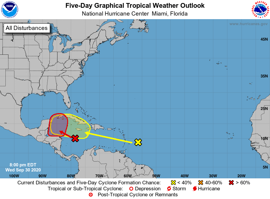
The National Hurricane Center (NHC) now believes the system in the central Caribbean has a high chance of evolving into a tropical cyclone over the next five days. This system. now a tropical wave located over the west-central Caribbean Sea. is expected to continue moving westward over the next couple of days, and produce a broad area of low pressure over the western Caribbean Sea or extreme southern Gulf of Mexico by Thursday night or Friday. The NHC says environmental conditions are forecast to be conducive for some development thereafter, and a tropical depression could form over the weekend while the system moves slowly west-northwestward over the northwestern Caribbean Sea. The NHC says interests in Belize, the Yucatan Peninsula, and western Cuba should monitor the progress of this disturbance in the coming days. While there’s only a 20% chance that this will develop into a tropical cyclone over the next 48 hours, there is a 70% chance that it’ll develop into one over the next five days.
The other system the NHC is concerned about is well east of the other. Another tropical wave located a few hundred miles east of the Lesser Antilles is producing widespread cloudiness and disorganized shower activity right now. This disturbance is forecast to move westward during the next several days where environmental conditions could become a little more conducive for development over the central or western Caribbean Sea by early next week. Any development will take time; while there’s no chance of tropical cyclone formation here over the next 48 hours, those odds grow to 20% over the next five days and could be higher than that beyond then.
While September 2020 ended quietly for Atlantic tropical cyclones, it produced a record 10 named storms during the month , breaking the old Atlantic September record of 8 named storm formations. The storms that developed this month in the Atlantic were Nana, Omar, Paulette, Rene, Sally, Teddy, Vicky, Wilfred, Alpha and Beta.
Because the typical list of names of storms was exhausted because the season is so busy, the National Hurricane Center is now using letters of the Greek alphabet to label storms once they become named tropical storms. The next two named storms will be called Gamma and Delta.
