• Skip to primary navigation
  • Skip to main content
  • Skip to primary sidebar

Weatherboy

Weatherboy Weather News, Maps, RADAR, Satellite, and Forecasts.

  • Local
  • Earth Science News
  • RADAR
  • Current Warnings
  • Satellite
  • Current Maps
  • Forecast Maps
  • Video

Gabrielle Forms in the Atlantic

by Weatherboy Team Meteorologist - September 4, 2019

Latest forecast track for Gabrielle in the Atlantic. Image: NHC


Tropical Storm Gabrielle has formed in the far central Atlantic, the 7th named storm of an increasingly busy Atlantic Hurricane Season. Fortunately, Gabrielle should not impact any U.S. interest.

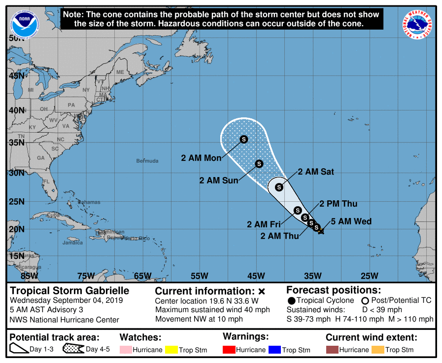
In the latest advisory from the National Hurricane Center this morning, the center of Tropical Storm Gabrielle was located near latitude 19.6 North, longitude 33.6 West. Gabrielle is moving toward the northwest near 10 mph  and this general motion is forecast to continue through Friday, with an increase in forward speed expected late in the week.


Tropical Storm Gabrielle is not expected to become a hurricane at this time. Maximum sustained winds are near 40 mph  with higher gusts. Some slight strengthening is forecast during the next 48 hours, but maximum sustained winds aren’t expected to reach hurricane strength at all over the next 3-5 days. Tropical-storm-force winds extend outward up to 90 miles  from the center. The estimated minimum central pressure is 1005 mb  or 29.68 inches of mercury.

On its current forecast track, Gabrielle should remain a “fish storm” and not impact the United States. However, Gabrielle’s position in the Atlantic could help steer a new system coming off the continent of Africa towards North America. That system, which if named would become Humberto, could bring severe hurricane conditions to portions of the Caribbean, the Bahamas, and/or the U.S. East Coast in less than 2 weeks.

Primary Sidebar

Sponsored Ad

Search

Latest News

  • Friday Smoke Forecast Looks Bad for Philadelphia, Baltimore, and Washington, DC
  • NOAA Announces the Official Arrival of El Nino
  • USGS Raises Volcano Alert Level to WARNING as Kilauea Volcano in Hawaii Erupts
  • Smoke Creating Very Hazardous Air Travel Conditions Around Philadelphia, Newark, and New York City Airports
  • Smoking 1/2 Pack of Cigarettes Healthier than Breathing in New York City’s Smoky Air Today; Same is True in Pennsylvania, New Jersey, and Other States
  • Smoke from Canadian Fires to Become More Thick in New Jersey, Pennsylvania, Connecticut, Rhode Island, and Massachusetts on Wednesday
  • Hurricane Center Monitoring Disturbance in Northeast Atlantic Ocean
  • USGS Raises Alert Level and Aviation Color Code for Volcano: ADVISORY / YELLOW
About | Careers | Contact | Contests
Terms | Privacy | Ad Choices
Weatherboy is a (R) Registered Trademark of isarithm LLC, All Rights Reserved.
All content herein is Copyright by Isarithm LLC 1997-2022