The remnants of Tropical Storm Harvey appear to be regenerating in the Gulf of Mexico and the National Hurricane Center (NHC) has upgraded the system back to Tropical Depression status; additional intensification is likely to a Tropical Storm and possibly a Hurricane, prompting new watches for the US Gulf Coast.
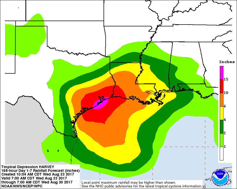
Satellite images, reconnaissance data and surface observations indicate that the remnants of Harvey redveloped into a tropical depression this morning over the southwestern Gulf of Mexico about 150 miles west of Merida, Mexico. The low is forecast to move to the northwest at about 10 mph across the western Gulf of Mexico, possibly reaching the northwestern Gulf coast late Friday. This system is likely to slow down once it reaches the coast, increasing the threat of a prolonged period of heavy rainfall and flooding across portions of Texas and Louisiana into early next week. Harvey could also produce storm surge and tropical storm or hurricane force winds along portions of the Texas coast later this week.
While there appears to be a serious threat with Harvey in the Gulf, meteorologists are also monitoring another disturbance near Florida. An area of disorganized showers and thunderstorms stretching across the Bahamas, southern Florida, and the adjacent waters is associated with a trough of low pressure. Any development of this system during the next few days should be slow to occur while it drifts northward over Florida and the adjacent waters. Environmental conditions could become a little more conducive for tropical or subtropical development over the weekend when the system begins to move northeastward over the western Atlantic. Regardless of development, very heavy rain and flooding is possible over portions of the Florida peninsula during the next few days.
Experts believe this Atlantic Hurricane Season, which runs through to the end of November, will be a busy one. Dr. Phil Klotzbach and the experts at Colorado State University updated their seasonal outlook again on July 5, showing a much more active than normal season expected. The National Oceanic and Atmospheric Administration (NOAA) also released their own forecast which shows this hurricane season to be likely more active than others.
