The death toll in Hawaii continues to climb, with at least 36 people confirmed dead on the island of Maui from a severe fire weather situation that unfolded earlier this week; while rescue and recovery and fire fighting missions continue, both the Central Pacific Hurricane Center and the National Hurricane Center are tracking additional tropical cyclone threats that could impact the weather in the Aloha State.
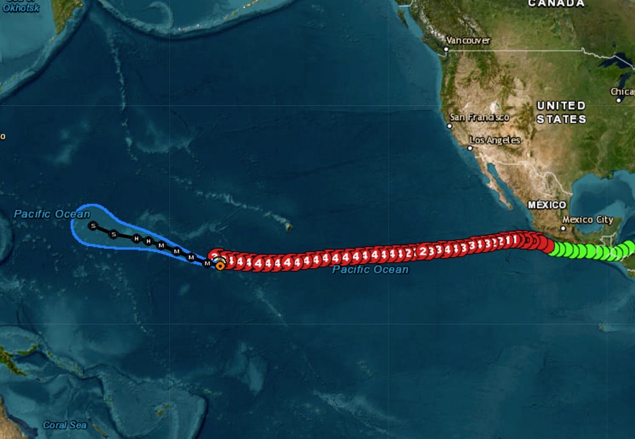
On Monday, a powerful category 3 hurricane moved well south of the Big Island of Hawaii while strong high pressure moved in from the north. The difference in air pressure between those two systems helped increase typical trade winds that blow through Hawaii to very high speeds. With sinking and drying air and unusually low humidity levels, conditions were ripe for fire weather, made worse by recent dry weather and drought conditions in Hawaii.
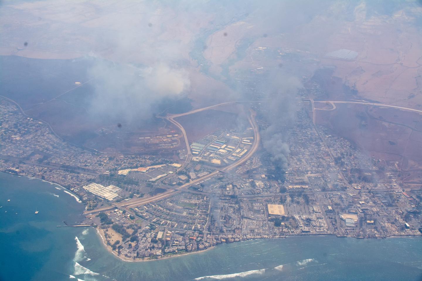
Both islands of Hawaii and Maui saw large scale fires form. On the Big Island of Hawaii, fire went through the communities of Kohala Ranch and Waimea as well as through the luxury oceanfront golf resort, Mauna Kea Beach. But the worst fires hit Maui, where multiple fires consumed thousands of acres of land including much of the town of Lahaina. Many fires were caused by wires and utility poles falling in high winds but fire officials have not had the opportunity to declare the source or cause of all fires impacting the state.
In Lahaina, the official death toll is at 36 but sources in Maui Fire Department tell us that more than 48 bodies were found just today in the rubble. Hundreds of people are missing and people are using social media desperate to get connected to missing family, friends, and co-workers while fearing for the worse. Fires continue to burn in Lahaina and nearby areas as well as elsewhere on the island.

Tourists are being evacuated from Maui and are either being sent to Honolulu on the island of Oahu or the U.S. mainland. United Airlines announced, “Safety is the first priority of our customers and employees, and we are closely monitoring the devestating conditions in Maui. Today’s flights to Kahului Airport (OGG) have been canceled so our planes can fly empty to Maui and be used to bring passengers back to the mainland.” Southwest and Hawaiian Airlines also introduced emergency $19 fares to people trying to escape Maui to another island.
Yesterday, through an emergency proclamation from the Governor’s office, non-essential travel to and around Maui was made illegal and tourists planning trips to Maui are being encouraged to cancel or change those plans.
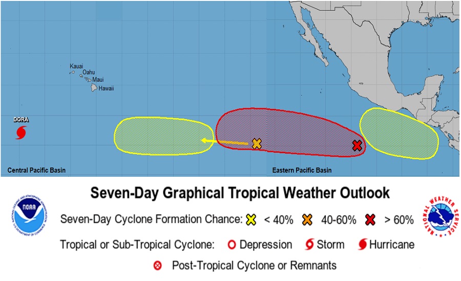
While fires continue to burn on Maui, meteorologists at the National Hurricane Center in Miami, Florida and the Central Pacific Hurricane Center in Honolulu, Oahu are tracking three potential systems of concern in the central and eastern Pacific hurricane basins.
Approximately 2,000 miles southeast of Hilo, Hawaii, a tropical wave is producing some disorganized showers and thunderstorms. According to the hurricane center, some gradual development of this system is possible during the next several days while it moves generally westward at 10 to 15 mph across the far western portion of the East Pacific basin
and into the Central Pacific basin. Fortunately, there is a low chance of formation from this disturbance; the National Hurricane Center says there’s a near-zero percent chance of formation over the next 48 hours but only a 20% chance over the next 7 days.
A system behind the first is of greater concern. The National Hurricane Center says there’s an 80% chance that this system will become a tropical cyclone sometime over the next 7 days. Now simply a tropical wave, the disturbance continues to produce a large area of disorganized showers and thunderstorms several hundred miles south-southwest of the coast of southwestern Mexico. According to the National Hurricane Center, “Environmental conditions appear conducive for gradual development of this system, and a tropical depression is likely to form late this weekend or early next week while it moves westward at about 15 mph across the central portion of the basin.”
The third system of concern also has improving odds of creating trouble and the National Hurricane Center says there’s a 50-50 chance that a tropical cyclone will form here too over the next seven days. According to the National Hurricane Center, an area of low pressure is forecast to form offshore of Central America in a few days. Environmental conditions are expected to be conducive for gradual development of this system, and a tropical depression could form during the early or middle part of next week while it moves generally west-northwestward, roughly parallel to the coast of southern Mexico.
The first two systems are predicted to move west towards Hawaii over the next 1-2 weeks. It is too soon to know whether there will be any direct or indirect impacts from the storms to the Hawaiian Islands.
Meanwhile, Hurricane Dora continues to head west away from Hawaii and Johnston Island. According to the last advisory from the Central Pacific Hurricane Center, the center of Hurricane Dora was located near latitude 12.7 North, longitude 173.0 West which is 1,160 miles west-southwest of Honolulu. Dora is moving toward the west-northwest near 20 mph. Dora is expected to continue moving towards the west-northwest over the next several days; on its forecast track, Dora will cross the date line into the west Pacific basin on Friday.
Dora is still packing a punch with maximum sustained winds of 120 mph with higher gusts, making it a category 3 hurricane on the Saffir-Simpson Hurricane Wind Scale. Slow weakening is forecast during the next 24 hours, followed by a more rapid weakening beyond 36 hours.
