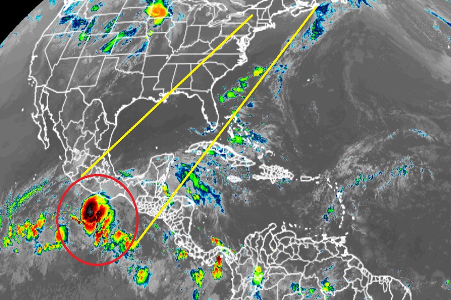
The National Hurricane Center is currently issuing advisories on Hurricane Agatha, the Eastern Pacfic Hurricane Basin’s first named storm of the 2022 Eastern Pacific Hurricane Center. While the storm system is expected to impact the Pacific coast of Mexico later on Monday, the remnants of the storm may reform into a tropical cyclone threat for Florida or portions of the U.S. East Coast with time. With the start of the Atlantic Hurricane Season officially arriving on June 1, it’s important that U.S. residents become prepared for anything Agatha’s remnants could do –or with any tropical cyclone threat in the coming weeks and months over a season that is forecast to feature an above-normal volume of storms.
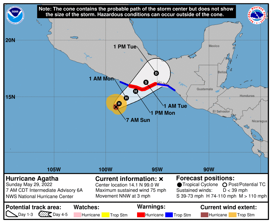
According to the latest advisory issued by the National Hurricane Center (NHC) in Miami, Florida, Agatha was located about 200 miles west-southwest of Puerto Angel, Mexico. With maximum sustained winds of 75 mph, Agatha is a Category 1 hurricane on the Saffir-Simpson hurricane wind scale. Agatha is moving to the north-northwest at 3 mph; its minimum central pressure is 987 mb or 29.15″.
With the arrival of the storm expected tomorrow on the coast, officials have issued a Hurricane Warning from Salina Cruz to Lagunas de Chacahua while a Hurricane Watch is in effect for Salina Cruz eastward to Barra De Tonala. A Tropical Storm Warning is in effect for Salina Cruz eastward to Boca de Pijijiapan and also for Lagunas de Chacahua westward to Punta Maldonado. A Hurricane Warning means that hurricane conditions are expected somewhere within the warning area within 36 hours. There, preparations to protect life and property should be rushed to completion. A Hurricane Watch means that hurricane conditions are possible within the watch area. A Tropical Storm Warning means that tropical storm conditions are expected somewhere within the warning area.

According to the NHC, Agatha is expected to turn toward the northeast later today, with a slow motion toward the northeast continuing through Monday night. On the forecast track, the center of Agatha will approach the southern coast of Mexico later today and make landfall there on Monday. Before landfall, the NHC says additional intensification is anticipated up until it strikes Mexico on Monday.
Right now, hurricane-force winds extend outward up to 20 miles from the center, and tropical storm-force winds extend outward up to 80 miles from the center.
In Mexico, hurricane conditions are expected in the Hurricane Warning area and possibly in the watch area on Monday, with tropical storm conditions beginning late tonight or early Monday. Storm surge is expected to produce dangerous coastal flooding in areas of onshore winds near and to the east of where the center of Agatha makes landfall. Near the coast, the surge will be accompanied by large and destructive waves.
Hurricane Agatha will also produce heavy rains over portions of southern Mexico by later today into Tuesday night. In the Mexican state of Oaxaca, 10-16″ of rain is likely to fall with isolated amounts to 20″. In the Mexican state of Chiapas, 5-10″ of rain is likely with isolated amounts up to 15″ possible. Life-threatening flash flooding and mudslides may occur.

Agatha is forecast to cross Mexico and weaken, with its remnants gradually moving into the Gulf of Mexico or Caribbean Sea. From there, computer models suggest the system could take on fresh tropical cyclone characteristics and develop, perhaps impacting the U.S. as a tropical storm or hurricane over time.
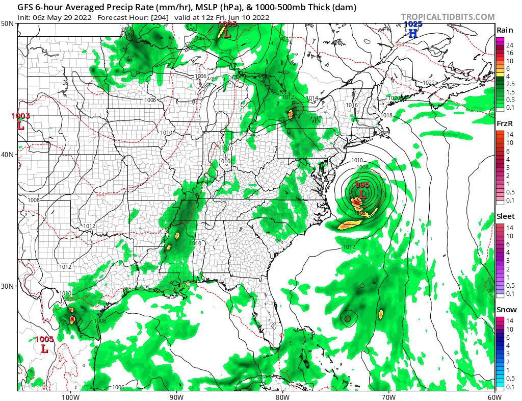
The latest American GFS computer forecast model suggests the storm will develop outside of the Bahamas and then re-curve back to the Mid Atlantic, impacting somewhere at or near the Jersey Shore as a new tropical storm or hurricane in about 10-12 days.
However, computer forecast guidance, especially as it relates to tropical cyclones, is prone to error this far out. While it is very possible Agatha’s remnants could do what the computer forecast models suggest it’ll do, there’s more than a week left for more accurate solutions to rise up and show where this system will likely go.
Nevertheless, with the Atlantic Hurricane Season just days away from starting on June 1, it’s imperative that everyone along the U.S. East and Gulf Coasts be prepared for that the 2022 Atlantic Hurricane Season may throw its way in the coming days and months.