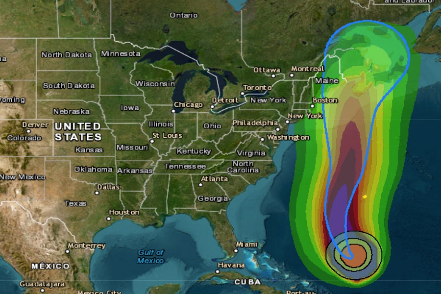
Hurricane Lee is forecast by the National Hurricane Center (NHC) to make direct impacts to portions of the northeastern U.S. and eastern Canada this weekend. There are no watches or warnings up at this time for the United States, but that could change in the coming days as Lee gradually comes north along the U.S. east coast. The government of Bermuda has issued a Tropical Storm Watch there though; as Lee passes between the U.S. and Bermuda, the island could be brushed by tropical storm force winds.
As of the latest advisory from the NHC, Major Hurricane Lee was a category 3 hurricane with maximum sustained winds of 115 mph and minimum central pressure of 946 mb or 27.94″. The storm is moving to the northwest slowly at 7 mph, a considerable slow-down from its movement in recent days.
The Tropical Storm Watch in effect for Bermuda means that tropical storm conditions are possible within the watch area, generally within 48 hours. Tropical storm force winds are not expected in the United States within the next 48 hours, hence no watches or warnings there.
While Lee is moving toward the northwest near 7 mph now, the NHC expects Lee to turn toward the north on Thursday and increase in forward speed.
Maximum sustained winds are near 115 mph with higher gusts. According to the NHC, some slow weakening is forecast during the next 48 hours, though the wind field will remain large.
Lee is very large hurricane. Hurricane-force winds extend outward up to 125 miles from the center and tropical-storm-force winds extend outward up to 240 miles. This wind field is expected to expand as the storm moves north and tropical storm force winds may be felt as far away as eastern New York as the storm moves north.
Swells generated by Lee are affecting portions of the Lesser Antilles, the British and U.S. Virgin Islands, Puerto Rico, Hispaniola, the Turks and Caicos Islands, the Bahamas, and Bermuda. These swells are likely to cause life-threatening surf and rip current conditions. Dangerous surf and rip currents are affecting portions of the southeastern U.S. coast, and these conditions are forecast to spread northward along much of the U.S. East Coast and Atlantic Canada during the next couple of days. Even expert swimmers and surfers should avoid the ocean until hazards from Lee are well over.
While the center of #HurricaneLee is due to approach near the mouth of the Bay of Fundy between Maine and Nova Scotia this weekend, extreme waves are likely over a broad area over many days. This will create a variety of hazards & damage along a wide part of the northeast coast. pic.twitter.com/P0Zt2xOrQh
— the Weatherboy (@theWeatherboy) September 13, 2023
According to the National Hurricane Center, it is still too soon to say with a high degree of certainty where exactly Hurricane Lee will make landfall. The official NHC forecast brings Lee as a hurricane just southwest of Nova Scotia by Saturday afternoon, with it ending up near Prince Edward Island, Canada by Sunday afternoon. However, the cone of uncertainty also extends west to Cape Cod and central and eastern Maine …and as far east as Cape Breton in Nova Scotia. People throughout this area should be prepared for impacts, although the worst impact zone isn’t yet known.
Even with the storm center far away, the large size of Lee, not to mention its expanding wind field, will whip up huge waves along and especially off-shore the northeast coast from North Carolina to Maine.