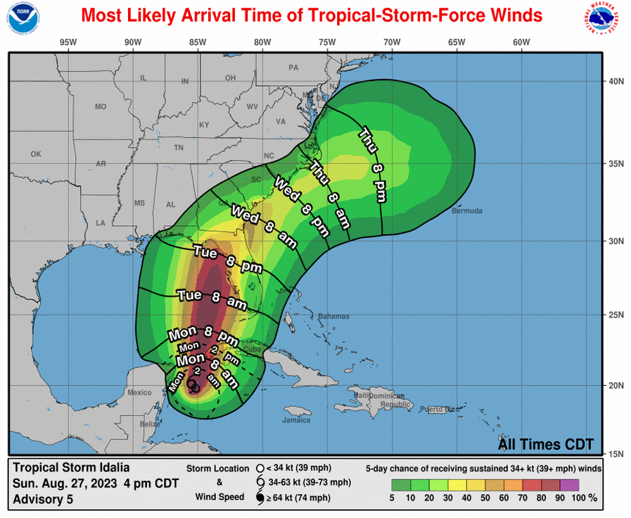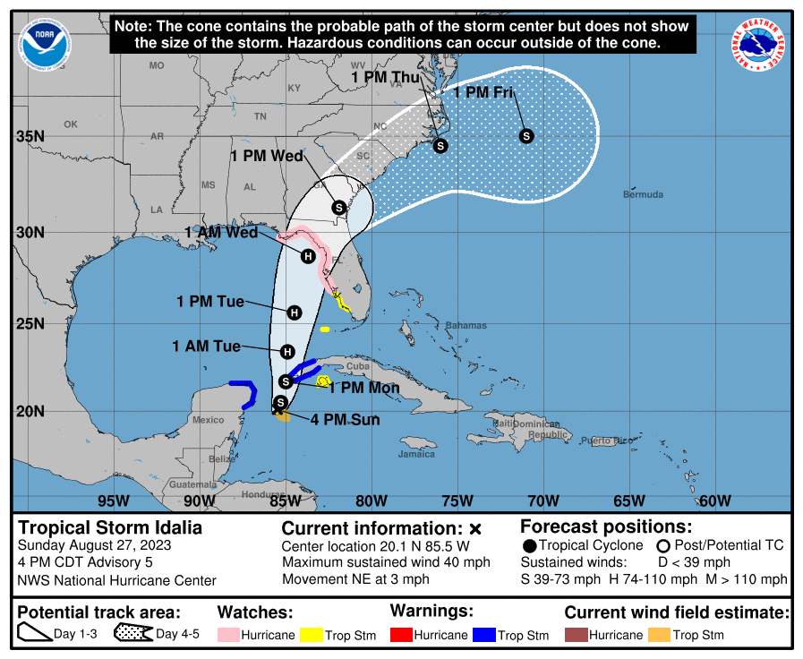
The National Hurricane Center in Miami, Florida has issued Hurricane Watches and Storm Surge Watches for portions of Florida ahead of Tropical Storm Idalia’s expected arrival. Idalia is forecast to strengthen into a hurricane by Tuesday morning and make a landfall into the Florida Gulf Coast by Wednesday morning, perhaps as a major hurricane.
As of the latest advisory from the National Hurricane Center (NHC), Idalia was a tropical storm with maximum sustained winds of 40 mph. The storm is drifting northeast at 3 mph while having a minimum central pressure of 995 mb or 29.39″. It is currently about 95 miles east-southeast of Cozumel, Mexico.
The NHC is forecasting the storm to be on a collision course with Florida and the southeastern United States. According to the NHC, slow, possibly erratic, motion is expected overnight. A generally northward to north northeastward motion at an increasing forward speed is expected on Monday and Tuesday. On the forecast track, the center will move over the eastern Gulf of Mexico on Monday and Tuesday, and approach the northeast Gulf coast late Tuesday. Strengthening is forecast by the NHC and Idalia is expected to become a hurricane over the southeastern Gulf of Mexico by early Tuesday. Additional strengthening is likely while Idalia approaches the northeastern Gulf coast.
Due to the forecast path, a Storm Surge Watch has been issued for the Gulf coast of Florida from Chokoloskee to Indian Pass, including Tampa Bay. A Hurricane Watch has been issued for the Gulf coast of Florida from Englewood to Indian Pass, including Tampa Bay. A Tropical Storm Watch has been issued for the Gulf coast of Florida south of Englewood to Chokoloskee, and for the Dry Tortugas.
A Storm Surge Watch means there is a possibility of life-threatening inundation, from rising water moving inland from the coastline, in the indicated locations during the next 48 hours.
A Hurricane Watch means that hurricane conditions are possible within the watch area. A watch is typically issued 48 hours before the anticipated first occurrence of tropical-storm-force winds, conditions that make outside preparations difficult or dangerous.
A Tropical Storm Warning means that tropical storm conditions are expected somewhere within the warning area while a Tropical Storm Watch means that tropical storm conditions are possible within the watch area.

“Interests along the southeastern U.S. coast should monitor the progress of this system,” the NHC warned. “Additional watches and warnings will likely be required on Monday.”
The NHC is suggesting that the storm surge could be quite significant. The combination of a dangerous storm surge and the tide will cause normally dry areas near the coast to be flooded by rising waters moving inland from the shoreline. The water could reach the following heights above ground somewhere in the indicated areas in Florida if the peak surge occurs at the time of high tide:
- Aucilla River to Chassahowitzka 7-11′
- Chassahowitzka to Anclote River 5-8′
- Ochlockonee River to Aucilla River 4-7′
- Anclote River to Middle of Longboat Key 3-5′
- Tampa Bay 3-5′
- Middle of Longboat Key to Chokoloskee 2-4′
- Charlotte Harbor 2-4′
- Indian Pass to Ochlockonee River 2-4′
- Chokoloskee to East Cape Sable 1-3′
- Florida Keys 1-2′
The deepest water will occur along the immediate coast in areas of onshore winds, where the surge will be accompanied by large and dangerous waves. Surge-related flooding depends on the relative timing of the surge and the tidal cycle, and can vary greatly over short distances.
In addition to hurricane force winds, Idalia is also expected to produce flooding rains over the southeast. For portions of the west coast of Florida, the Florida Panhandle, and southern Georgia from Tuesday into Wednesday, 3-6″ is expected, with isolated higher totals of 10″ possible. Heavy rainfall is also likely to spread into portions of the Carolinas by Wednesday into Thursday. This rainfall may lead to flash and urban flooding across portions of the west coast of Florida, the Florida Panhandle and portions of the Southeast U.S. by Tuesday into Thursday.