The National Hurricane Center has upgraded advisories along portions of the Gulf Coast to Hurricane Warnings as Tropical Storm Barry inches closer to the coast. Even if Barry doesn’t become a major hurricane, and it isn’t forecast to do so, it will produce massive flooding problems across Louisiana including New Orleans, which could see flooding not seen since Hurricane Katrina in 2005.
Numerous advisories are up ahead of Barry’s arrival. A Hurricane Warning is in effect for Intracoastal City to Grand Isle in Louisiana. A Hurricane Warning means that hurricane conditions are expected somewhere within the warning area. A warning is typically issued 36 hours before the anticipated first occurrence of tropical-storm-force winds at which point conditions that make outside preparations difficult or dangerous occur. Preparations to protect life and property should be rushed to completion here. A Tropical Storm Warning is in effect for the mouth of the Pearl River to Grand Isle, Lake Pontchartrain and Lake Maurepas including metropolitan New Orleans, and Intracoastal City to Cameron. A Tropical Storm Warning means that tropical storm conditions are expected somewhere within the warning area within 36 hours. A Storm Surge Warning is in effect for the Mouth of the Atchafalaya River to Shell Beach. A Storm Surge Warning means there is a danger of life-threatening inundation from rising water moving inland from the coastline during the next 36 hours in the indicated locations. A Storm Surge Warning event is a life-threatening situation; persons located within these areas should take all necessary actions to protect life and property from rising water and the potential for other dangerous conditions. People in a Storm Surge Warning area should promptly follow evacuation orders and other instructions from local officials. A Storm Surge Watch is in effect for Shell Beach to the Mississippi/Alabama border, from the mouth of the Atchafalaya River to Intracoastal City, and for Lake Pontchartrain. A Storm Surge Watch means there is a possibility of life-threatening inundation from rising water moving inland from the coastline in the indicated locations during the next 48 hours. A Hurricane Watch is in effect for an area stretching from the mouth of the Mississippi River to Grand Isle and from Intracoastal City to Cameron while a Tropical Storm Watch is in effect for the area east of the mouth of the Pearl River to the Mississippi/Alabama border. Hurricane and Tropical Storm Watches are issued 48 hours before the first occurence of tropical storm conditions; in a hurricane watch, it’s possible to see conditions worse than tropical storm strength in 48 hours.
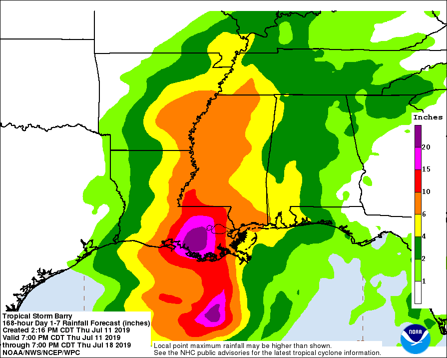
Barry may not be an intense storm, but it is a slow-moving storm with an extreme amount of moisture associated with it. Because it is entering an area that has seen very heavy rainfall in recent weeks and rivers, including the Mississippi are much higher than normal, the flood threat will be that much greater. The National Weather Service believes more than 20″ of rain could fall from this slow-moving system which could create catastrophic flooding conditions, including in the city of New Orleans.
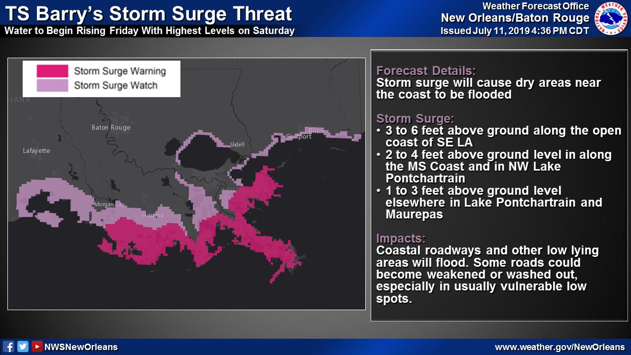
In addition to extremely heavy rains, Barry is likely to push a significant storm surge onto land, submerging coastal areas in salt water that’ll be measured in feet or yards.