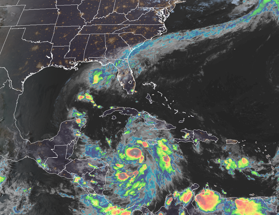
More Hurricane Warnings are now up ahead of Delta, the latest storm from a record breaking 2020 Atlantic Hurricane Season. When Delta formed this morning, it became the 25th named storm of the 2020 Atlantic #hurricane season, making it the earliest 25th Atlantic named storm on record. The old record was November 15, 2005. The National Hurricane Center is forecasting that Delta will also go through a period of rapid intensification; such a forecast brings maximum sustained winds of the system to a major hurricane with 120 mph winds. If that forecast verifies, Delta would become the strongest Greek named hurricane in the Atlantic on record, breaking the old record set by 2005’s Beta which had 115 mph maximum sustained winds.
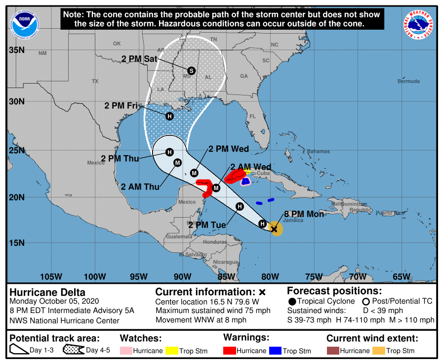
For now, Hurricane Delta is located at 16.5N, 79.4W, which puts the center roughly 150 miles south-southwest of Negril, Jamaica and about 220 miles south-southeast of Grand Cayman. Maximum sustained winds are 75 mph while the minimum central pressure is now down to 980 mb or 28.94 inches.
With strengthening happening now and additional rapid intensification expected soon, Hurricane Warnings have been issued for Delta for the Cuban province of Pinar del Rio, Cozumel, Mexico, and from Tulum to Rio Lagartos in Mexico. A Hurricane Watch is in effect for the Cayman Islands including Little Cayman and Cayman Brac and the Isle of Youth. A Tropical Storm Watch is in effect for the province of La Habana in Cuba. A Hurricane Warning means that hurricane conditions are expected somewhere within the warning area. A warning is typically issued 36 hours before the anticipated first occurrence of tropical-storm-force winds, conditions that make outside preparations difficult or dangerous. Preparations to protect life and property should be rushed to completion within the Hurricane Warning area. A Hurricane Watch means that hurricane conditions are possible within the watch area, generally within 48 hours. A Tropical Storm Warning means that tropical storm conditions are expected somewhere within the warning area within 36 hours. A Tropical Storm Watch means that tropical storm conditions are possible within the watch area, generally within 48 hours.

While Delta is moving toward the west -northwest at 8 mph now. A faster northwestward motion is expected Tuesday through Wednesday night. On the forecast track, the center of Delta is expected to pass southwest of the Cayman Islands early Tuesday, and approach the northeastern portion of the Yucatan peninsula and the Yucatan Channel Tuesday afternoon or evening. Delta is forecast to move into the southern Gulf of Mexico Tuesday night or early Wednesday, and be over the south-central Gulf of Mexico on Wednesday and Wednesday night.
While Delta is a Category 2 Hurricane now, additional rapid strengthening is expected during the 24 hours and Delta is expected to be a major hurricane when it nears the Yucatan Peninsula. Delta is forecast to strike the U.S. Gulf Coast by the end of the week as a significant hurricane, which alone will break another record for most landfalling storms in a single hurricane season in the Atlantic basin.
Before Delta arrives in the U.S., storm surge, damaging winds, and flooding rains are expected in portions of the Caribbean and Mexico. A dangerous storm surge will raise water levels by as much as 4-7′ above normal tide levels along coast of the Yucatan peninsula within the hurricane warning area, near and to right of where the center makes landfall. Near the coast, the surge will be accompanied by large and dangerous waves. Tropical storm wind conditions are expected in the Cayman Islands beginning tonight. Hurricane conditions are expected within the hurricane warning area in the Yucatan Peninsula Tuesday night, with tropical storm conditions beginning late Tuesday. Hurricane conditions are expected within a portion of the the Hurricane Warning area in western Cuba by late Tuesday night, with tropical storm conditions expected beginning late Tuesday. Hurricane conditions are possible on the Isle of Youth beginning Tuesday afternoon with tropical storm conditions expected by early Tuesday. Tropical storm conditions are possible in the Tropical Storm Watch area in Cuba on Tuesday. Through midweek, Delta is expected to produce 3-6″ of rain with isolated maximum totals of 8″ across Jamaica, the Cayman Islands, western Cuba and the northern Yucatan Peninsula. This rainfall could lead to significant flash floods and mudslides. Later this week into the weekend, Delta is expected to bring heavy rainfall across portions of the central Gulf Coast into the southeastern United States.
While the National Hurricane Center’s intensity forecast calls for rapid intensification over the next day or so, and Delta is forecast to be a major hurricane when is passes near or over the northeastern portion of the Yucatan peninsula, once the storm reaches the central Gulf of Mexico in 60-72 hours, increasing southwestern vertical wind shear and cooler shelf waters over the northern Gulf are likely to result in some reduction in wind speed as the system nears the northern Gulf coast. Although there is still significant uncertainty regarding Delta’s intensity when it nears the northern Gulf coast, it is becoming increasing likely that the system will pose a significant wind and storm surge threat to a portion of that area.
While this area has been hit by several tropical cyclones this season, people cannot let their guard down. People in Louisiana and Mississippi are urged to prepare their hurricane action plans, re-stock necessary supplies, and re-evaluate what they should do if the storm threatens them at the end of the week.