Government officials have have started to issue advisories for Tropical Storm Isaac. While the storm reached hurricane status for a time yesterday, it weakened to tropical storm status. The National Hurricane Center is forecasting another strengthening period which would bring it back to hurricane status by tomorrow morning. While it could weaken back to tropical storm status, some officials are concerned it could remain a hurricane.
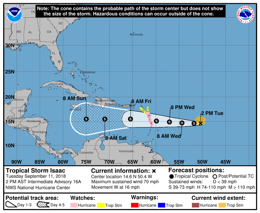
Right now, a Hurricane Watch is in effect for Guadeloupe, Martinique, and Dominica while a Tropical Storm Watch is in effect for Antigua, Montserrat, St. Kitts, and Nevis. A Hurricane Watch means that hurricane conditions are possible within the watch area. A watch is typically issued 48 hours before the anticipated first occurrence of tropical-storm-force winds, conditions that make outside preparations difficult or dangerous. A Tropical Storm Watch means that tropical storm conditions are possible within the watch area, generally within 48 hours.
Interests elsewhere in the Leeward Islands should monitor the progress of Isaac as additional watches could be issued this afternoon or evening. At 2:00 PM AST the center of Tropical Storm Isaac was located with high-resolution GOES-16 visible satellite data near latitude 14.6 North, longitude 50.4 West. Isaac is moving toward the west near 16 mph and this motion is expected to continue for the next few days. According to the National Hurricane Center, Isaac is anticipated to move near or over the central Lesser Antilles on Thursday and move into the eastern Caribbean Sea Thursday night. Maximum sustained winds remain near 70 mph with higher gusts. Isaac is expected to be near hurricane strength when it
moves through the central Lesser Antilles, with some weakening forecast afterward on Friday. Tropical-storm-force winds extend outward up to 105 miles from the center. The estimated minimum central pressure is 996 mb or 29.42 inches.
