Hurricane Watches are up for the U.S. and British Virgin Islands as Ernesto intensifies; the National Hurricane Center (NHC) believes Ernesto will become a hurricane tonight and will likely impact Bermuda in the coming days. For now, it is a tropical storm.
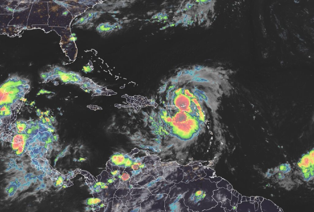
According to the latest update from the NHC, Ernesto was about 35 miles northwest of St. Thomas and 60 miles east-northeast of San Juan, Puerto Rico. Maximum sustained winds are 65 mph while the minimum central pressure is down to 998 mb or 29.47″. The storm is moving northwest at 17 mph.
A Hurricane Watch is in effect for the U.S. Virgin Islands, the British Virgin Islands, and Vieques and Culebra. A Hurricane Watch means that hurricane conditions are possible within the watch area, in this case through tonight.
A Tropical Storm Warning is in effect for the British Virgin Islands, the U.S. Virgin Islands, Puerto Rico, Vieques, and Culebra. A Tropical Storm Warning means that tropical storm conditions are expected somewhere within the warning area within 36 hours.
No watch is in effect for Bermuda at this time, but the National Hurricane Center cautions, “Interests in Bermuda should monitor the progress of Ernesto.”
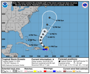
According to the NHC, Ernesto should turn toward the north-northwest and north with a gradual decrease in forward speed on Wednesday night and Thursday. On the forecast track, the center of Ernesto will pass to the northeast and north of Puerto Rico through early Wednesday. Ernesto should then move over the western Atlantic later in the week and approach Bermuda on Friday and Friday night. Strengthening is forecast during the next several days, and Ernesto is expected to become a hurricane by early Wednesday to the north of the Virgin Islands and Puerto Rico.
Ernesto is expected to produce total rain accumulations of 4-6″ over the U.S and British Virgin Islands. Rainfall totals of 6-8″, with maximum amounts of 10″, are expected across southeastern Puerto Rico, with totals of 2-4″ across northwestern Puerto Rico.
Tropical storm conditions will continue spreading across the Virgin Islands, Puerto Rico, Vieques, and Culebra through the overnight hours. Hurricane conditions are possible in portions of the watch area during the next several hours.
A storm surge will raise water levels by as much as 1 to 3 feet above ground level for the eastern coast of Puerto Rico from San Juan to Guayama, including the islands of Culebra and Vieques and in the U.S. Virgin Islands, including St. Thomas, St. John, and St. Croix. A storm surge will also raise water levels by as much as 1 to 3 feet above normal tide levels in the British Virgin Islands. In both cases, near the coast, the surge will be accompanied by large and destructive waves.
Swells generated by Ernesto are affecting portions of the Leeward Islands, the Virgin Islands, and Puerto Rico. These swells will reach the Dominican Republic overnight, the Turks and Caicos Islands and southeastern Bahamas on Wednesday, and Bermuda and the rest of the Bahamas on Thursday. Swells are expected to reach the east coast of the United States Thursday night and continue into the weekend. These swells are likely to cause life-threatening surf and rip current conditions.
