
Most the country has been in the Deep Freeze over the past 5 days or so, with temperatures 10 degrees or more below normal being found over a large swath of the country. As the Bering Sea Rule advertised around the New Year holiday, the pattern will be in the process of changing this week with Pacific air trying to move in over the Lower 48 thanks to southwest flow aloft.
The process of changing one distinct weather pattern to another is often a time of stormy weather and that is exactly what is in store for some of the Lower 48 over the next 7 days. Unlike this past weekend which brought a major snowstorm to the East Coast with heavy snow the primary travel threat, freezing rain and sleet (often grouped together under the term of ice) may be the greatest threat this time around. We will see a series of Canadian high pressure systems that will have plenty of cold air available to them travel west to east across southern Canada and the northern part of the Lower 48. As the same time, higher up in the atmosphere. southwest winds will be pushing in milder, Pacific air on top of the cold dome of air at the surface. This is a recipe for ice as a series of disturbances push southwest to northeast across the country.
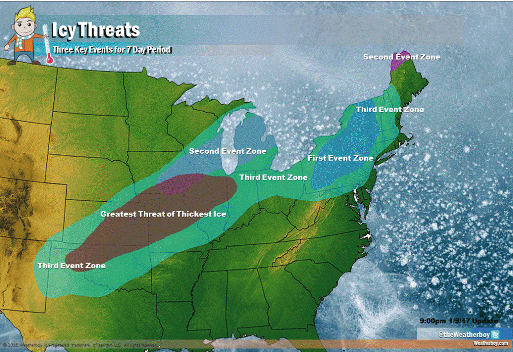
A weak icing event will occur during the day on Tuesday across parts of the interior Northeast. However, all you need is a little ice on the roads to potentially cause a big problem so this system deserves our attention. In the big scheme of things, this ice event is just an appetizer for a bigger system coming a couple of days later.
A second icing event is possible Wednesday night into Thursday from northern Illinois northeastward into central Michigan, southern Ontario and Quebec. Areas that saw ice on Tuesday look to be too mild this time around and will likely only see some light rain, fog and drizzle.
The third and potentially most significant ice event looks to begin on Friday. Ice from this event is going to possible in a huge swath of the country, from western and northern Texas northeastward into Missouri and Illinois and then east just north of the Ohio River, into the Great Lakes and into interior parts of the Northeast and mid-Atlantic. It is unusual to see such a large swath of land be affected be ice.
The weather setup on Friday includes a strong, Canadian area of high pressure which will build over the northern Plains. At the same time, a Pacific disturbance will be heading northeast from the Desert Southwest. In the worst of ice setups, your source of cold air is fresh and getting stronger. That is exactly what is happening with this arctic high pressure system. It will be over land covered by snow and right at the heart of climatological winter. This high pressure system will not want to budge and the warmer, Pacific air will slide right over the top of the arctic air in place at the surface. This is a classic setup for ice.
The region that is expected to see the brunt of this long-lived ice event will be western and northern Texas northeastward into Oklahoma, northwestern Arkansas, much of Kansas and southeastern Nebraska and central areas of both Missouri and Illinois. In this area, there is the potential to see over an inch of frozen precipitation and for it to occur over an extremely long time, in some cases 48 hours.
The threat of ice brings with it a handful of problems. First and foremost, untreated roads covered with ice become virtually impassable. Traction on ice is basically nonexistent. Professional drivers would much rather travel on snowy roads than icy ones. Secondly, this much ice will bring down trees and power lines. Power outages will be possible. Many people depend on electricity for either a primary or secondary heating source so keeping warm may become an issue for some.
With the huge area of ice expected, power crews will be on alert around the country and may need to travel long distances for the repair of the electricity grid. The sheer number of problem areas may mean that these crews will be spread too thin and power outages could last days or weeks. Preparations should be made now if you are in one of these affected regions. A generator is a terrific item to have in ice storms.
Ice is a very difficult forecast, especially this far out, and a change in temperature could change freezing rain to sleet or snow, or even to just plain rain. Also, areas that are in valleys away from urban areas are more prone to significant icing events.
Generally, icing events are isolated and are hard to predict hours, never mind days, in advance. This is an extremely rare situation where we can see the potential for large amounts of ice and are confident where and when it will happen. Agriculture, energy and government programs could be able to take advantage of this rare warning well in advance of the storm and prepare themselves for this potential disaster.