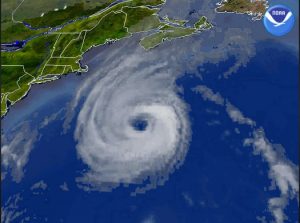
As we saw in 2016 with Hurricane Hermine in the Mid-Atlantic and Northeast and Hurricane Matthew in the Southeast, hurricane forecasts have room for improvement. This is especially true when they get as far north as the mid-latitudes and variables such as the jet stream get thrown into the mix.
The Woods Hole Oceanographic Institute (WHOI), located on Buzzards Bay in southeastern Massachusetts, in cooperation with scientists from Rutgers University, the University of Maine, the University of Maryland as well as CINAR (Cooperative Institute for the North Atlantic Region) pooled their resources on a project called TEMPEST (The Experiment to Measure and Predict East Coast Storm Strength). According to WHOI senior scientist , TEMPST had three main tools at its disposal. They are undersea gliders, buoys and ALAMO(Air-Launched Autonomous Micro Observer) floats that are released from NOAA’s hurricane hunter aircraft. According to Mr. Gawarkiewicz, a physical oceanographer, TEMPEST studied in depth the factors that contribute to storm intensity, including ocean geography, temperature, salinity, oxygen levels, water layer mixing, coastal water levels and wave patterns. The goal was to improve the intensity forecast of both tropical systems and winter storms.
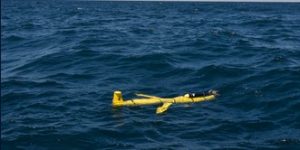
To improve the forecast of a tropical system, TEMPEST needed data from when it was affecting the region. In the past, this is exactly when data was most limited. Commercial ships and planes continually send data back to NOAA (the National Oceanic and Atmospheric Administration) but avoid the area of a hurricane or tropical storm for obvious reasons. This is where TEMPEST’s technology came into play. They released their gliders, which swim through the water, buoys, and floats when the tropical systems were near.

The gliders are manufactured by Teledyne Webb Research, based in Falmouth, Massachusetts. During a tropical system or winter storm, they were deployed off of Martha’s Vineyard, off the coast of Maine, near Atlantic City, New Jersey, and also Ocean City, Maryland. These gliders take measurements underwater across the continental shelf in water approximately 100 – 300 feet deep. The glider is capable of sustaining itself at sea for about one month. This technology was used for both Hurricane Arthur and Hurricane Hermine in 2016 as these storms passed close to the Northeast.
The most surprising result of the study using the gliders for these specific tropical systems is how big of a role the continental shelf plays in the weakening or strengthening of a tropical system. According to Mr. Gawarkiewicz, “In the summer months, a cold pool of water sets under a warm surface layer where the continental shelf ends. It does not take much to bring this cool pool to the surface. A slow moving tropical system with bands of rain and wind that extend well to the north of the center of the storm can bring this cool water up to the surface ahead of the hurricane and cause it to weaken as it travels over it. Hurricane Irene in August 2011 is a great example of this.” As a result, Irene dramatically weakened as it moved northward.
In contrast to Irene was Superstorm Sandy. Occurring in late October, the ocean had already mixed, thus there was no cooler water to bring to the surface. Even with the water being churned up, Sandy did not weaken as it headed towards the coast. During the summer months, a tropical system moving fast or being rather compact won’t have as much of a chance of churning up the waters ahead of it, meaning it will sustain its strength longer than a storm like Irene.

Another asset TEMPEST employs are buoys that will measure winds, wave and sea levels both before and after a tropical system or winter storm. The goal of the buoys is to try and gather as much data as possible and combine this information with the other sources of data, such as the gilders mentioned above, satellite and radar images, and the data from NOAA’s hurricane hunting aircraft. At the present time, the team at TEMPEST is analyzing data, looking at the forecast of the storm and comparing it to the actual track and intensity of the tropical system or winter storm to try to pick up some subtle clues as to what could of been done better.
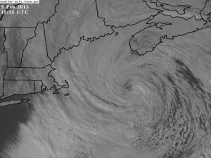
Though the meteorological factors of a winter storm are far different than a tropical system, some of the results to the average person living in the Northeast are the same. Of course, the forecasts for these winter storms, often called Nor’easters, leave room for improvement.
The buoys used by TEMPEST played a bigger role in the winter storms than they did during tropical systems. “Recreational boaters unknowingly severed the cables to many of these buoys in the days leading up to the approach of tropical system,” added Mr. Gawarkiewicz, “but there usually are not many of these boaters out during the heart of winter.” Developed by a team from the University of Massachusetts at Dartmouth, these buoys were able to give far more detailed data than previously recorded in other winter storms. Placed near Scituate, Massachusetts, Mr. Gawarkiewicz said, “The recorded wave heights were almost 11 meters (well over 30 feet) during the peak of a February 2015 Nor’easter, much higher than previously thought. And this was only hundreds of yards offshore. Recorded sea surface temperatures were in the 2-3 Celsius range above average and thus surplus warmth added more energy to this unusually strong storm.”
The ALAMO floats that were released from hurricane hunting aircraft added valuable, detailed data that were not only digested by the TEMPEST team but were sent to NOAA officials who added that data into various computer weather models. “This data provided by the ALAMO floats proved not only invaluable to our team but hopefully improved the forecasts for Arthur and Hermine”, Mr. Gawarkiewicz said.