Life-threatening floods are likely as a system in the Gulf, now known as Potential Tropical Cyclone #3, makes landfall over the next 24 hours. The National Hurricane Center in Miami, Florida is tracking the disturbance and wants the public to know two key points:The system is expected to produce heavy rainfall, considerable flash, urban and small stream flooding beginning today and continuing through the weekend along the Central Gulf coast. Flood impacts will spread northeastward into the Southern Appalachians with time. The second point is that tropical storm conditions are expected to begin later today in areas near and well to the east of the center along portions of the central Gulf Coast from east of Morgan City, Louisiana, to the Okaloosa/Walton County line, Florida, including New Orleans.
With tropical storm conditions arriving, the National Hurricane Center has Tropical Storm Warnings up for portions of the coast. A Tropical Storm Warning means that tropical storm conditions are expected somewhere within the warning area, in this case within the next 6-12 hours. They are currently up for the areas east of Morgan City, Louisiana to the Okaloosa/Walton County line in Florida and also include Lake Pontchartrain, Lake Maurepas, and the Metropolitan New Orleans area.
In the latest update from the National Hurricane Center (NHC), the storm was moving to the north at 14 mph, had maximum sustained winds of 45 mph, and a minimum central pressure of 1007 mb or 29.74″. The NHC says that satellite data indicates that maximum sustained winds have increased while the circulation is becoming gradually better defined; this means a tropical storm is likely to form over the north-central Gulf of Mexico later today or tonight. When that happens, this system will be named Tropical Storm Claudette.
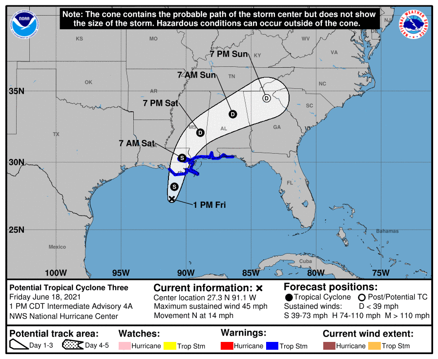
Right now, the system is moving toward the north near 14 mph and a north to north-northeast motion is expected during the next day or so. On the forecast track, the system will make landfall along the north-central Gulf Coast tonight or early Saturday. A northeastward motion across the southeastern United States is likely after landfall through the weekend.
The storm will bring flooding rains, dangerous storm surge, damaging winds, and isolated tornadoes with it.
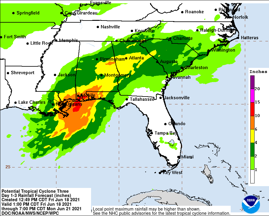
Rainfall totals of 4-8″ with isolated maximum amounts of 12″ are expected across portions of the Central Gulf Coast beginning today. Considerable flash, urban and small stream flooding impacts as well as new and renewed minor to isolated moderate river flooding are likely. As the system continues to lift northeast through the weekend, heavy rain will expand across southeastern Mississippi, southern and central Alabama, and central Georgia resulting in rainfall totals of 3-5″ with isolated maximum amounts of 7″. Flash, urban, small stream and isolated minor river flooding impacts are possible even well inland.
The combination of storm surge and the tide will cause normally dry areas near the coast to be flooded by rising waters moving inland from the shoreline. If peak surge occurs at high tide, the water could rise 2-3′ from the Morgan City, LA to Okaloosa / Walton County Line, Florida coast, Lake Borgne, and Mobile Bay. 1-2′ storm surge is possible in Lake Pontchartrain and Lake Maurepas. The NHC says surge-related flooding depends on the relative timing of the surge and the tidal cycle, and can vary greatly over short distances.
Potentially damaging tropical storm force winds are beginning to reach the coast now within the warning area. These winds will continue to pick up through tomorrow.
The NHC says there is a threat for a tornado or two this afternoon across coastal Louisiana, spreading overnight into Saturday across southern portions of Louisiana, Mississippi, Alabama, and the western Florida Panhandle.
