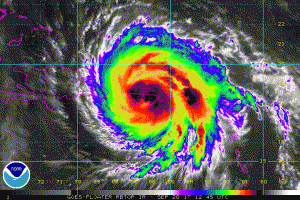
Major Hurricane Maria slammed into the United States this morning, making landfall near Yabucoa, Puerto Rico, around 6:15am AT with maximum sustained winds of 155 mph. Based on minimum central pressure, Hurricane Maria is the most intense hurricane to ever strike Puerto Rico, exceeding the potency of the 1928 Hurricane, also known as the San Felipe II storm, which later became known as the Great Okeechobee Hurricane. With maximum sustained winds just 2 mph shy of Category 5 status, Major Hurricane Maria struck Puerto Rico as a high-end Category 4 hurricane on the Saffir-Simpson wind scale. Authorities on the island are expecting Maria to be the worst natural disaster ever recorded on the island.
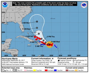
The storm is passing just southwest of San Juan, bringing the worst of the storm to the most populated regions of the island today. As of 9am AT, the center of Hurricane Maria was located at 18.3N 66.3W which is about 15 miles west south west of San Juan and about 30 miles east south east of Arecibo. Maximum sustained winds have dropped from their overnight peak of 175mph down to 145mph, with higher gusts. The storm continues to push on a destructive path across Puerto Rico in a northwest direction at 13mph. Minimum central pressure is now up to 927mb.
The storm lashed St. Croix last night, sending the United States Virgin Island into darkness. Little is known right now about the status of the island or its people, but early weather analysis shows it was quite the meteorological nightmare there last night. A weather station in western St. Croix reported sustained winds of 71mph with a gust to 137mph shortly before 3am. Most weather reporting stations on the island have failed to report, either reflecting their damage or cuts to their communication networks since then.
First images are now coming out of storm ravaged Dominica. Hartley Henry, Principal Advisor to Prime Minister Roosevelt Skerrit, wrote this morning, “The country is in a daze –no electricity, no running water– as a result of uprooted pipes in most communities and definitely to landline or cellphone services on island, and that will be for quite a while.” Henry also added that initial reports confirmed at least 7 deaths, but with communication fractured, that number is likely to rise. The Caribbean Disaster Emergency Management Agency reported after an aerial inspection that 100% of structures on the island were damaged, with at least 20% destroyed completely. Dominica was still recovering from Tropical Storm Erika, which killed 30 people and destroyed more than 370 homes in August 2015.

Beyond a destructive assault on Puerto Rico, meteorologists are concerned with Major Hurricane Maria’s future track. The official forecast from the National Hurricane Center lifts the storm north and west over time and gradually turns it more north. On this path, Maria would impact the north coast of the Dominican Republic and the southeastern Bahamas, both areas hit hard by Hurricane Irma just over a week ago. Because of this track, a variety of watches and warnings are in effect.
A Hurricane Warning is in effect for:
- U.S. Virgin Islands
- British Virgin Islands
- Puerto Rico, Culebra, and Vieques
- Dominican Republic from Cabo Engano to Puerto Plata
- Turks and Caicos Islands and the Southeastern Bahamas
A Tropical Storm Warning is in effect for:
- Saba
- St. Maarten
- St. Martin and St. Barthelemy
- Dominican Republic west of Puerto Plata to the northern border of the Dominican Republic and Haiti
- Dominican Republic west of Cabo Engano to Punta Palenque
A Hurricane Watch is in effect for:
- St. Maarten
- Dominican Republic from Isla Saona to Cabo Engano
The watches and warnings have various meanings. A Hurricane Warning means that hurricane conditions are expected somewhere within the warning area. Preparations to protect life and property should be rushed to completion. A Tropical Storm Warning means that tropical storm conditions are expected somewhere within the warning area. A Hurricane Watch means that hurricane conditions are possible within the watch area. A watch is typically issued 48 hours before the anticipated first occurrence of tropical-storm-force winds, conditions that make outside preparations difficult or dangerous.
Beyond the next 5 days, meteorologists are not yet certain where Maria will go. Current guidance suggests two potential paths: a storm track that brings Maria dangerously close to the northeast coast, but keeps the center off-shore -or- a storm system that brings the storm onto land somewhere in the Mid Atlantic. The picture of Major Hurricane Maria’s future will become more clear this weekend once the influence of the land of Puerto Rico and the Dominican Republic no longer influence the track or intensity of the storm.
Because of potential threats to the US East Coast, residents anywhere from Florida to Maine should have their Hurricane Action Plan in order; it may become necessary to act on it next week.
Experts believe this Atlantic Hurricane Season, which runs through to the end of November, will be a busy one. Dr. Phil Klotzbach and the experts at Colorado State University updated their seasonal outlook again on July 5, showing a much more active than normal season expected. The National Oceanic and Atmospheric Administration (NOAA) also released their own forecast which shows this hurricane season to be likely more active than others.