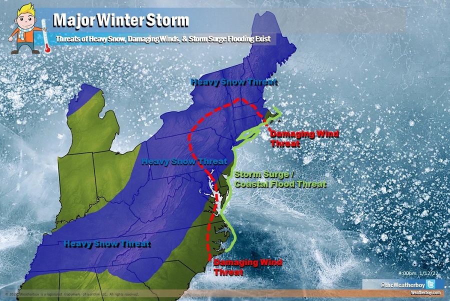
A major winter storm is likely to impact portions of the eastern United States in the coming days; it is also becoming likely there could be damaging impacts from storm surge flooding and destructive winds. While many questions remain with the upcoming storm with regards to precipitation types and amounts, confidence is increasing among meteorologists that a very significant winter storm will be moving through over the weekend into Monday.
While there are many unknowns still about this forecast, there are plenty of knowns. First, an Arctic cold front progressing through the Mid Atlantic on Friday will bring very cold temperatures back to the northeast, with dangerously low wind chills possible. The greatest threat of dangerous wind chills will be across the Poconos, northwestern New Jersey and points north and west from there into New England. This cold air will linger throughout the day Saturday as temperatures in the northeast stay below freezing. Temperatures north and west of I-95 will struggle to reach the low 20’s for a daytime high.
Meanwhile, energy will be moving down from the Upper Midwest on Saturday morning, helping to spawn a robust area of low pressure near Arkansas by Saturday afternoon. As this storm system takes shape, snow will break out across portions of Nebraska, Oklahoma, Missouri, southern Illinois, and Kentucky. As cold air wraps behind this storm, rain falling across portions of Arkansas, Tennessee, and even portions of Louisiana and Mississippi will change over to snow.
By Sunday afternoon, this storm system will be moving across the southeast, redeveloping and intensifying as it hits the coastal plain. It is at this point many forecast questions remain.

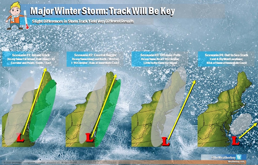
The movement of the low pressure system near the coastal plain will be key to determining precipitation types and amounts as the storm ejects out of the southeast and moves up the northeast coast. A track well inland will keep snow confined inland while milder air from the Atlantic keeps precipitation in liquid form along and to the south and east of the I-95 corridor. In this scenario, places like New York City and Boston could see mainly rain while very heavy snow, in excess of a foot, could accumulate far inland. A track that hugs the coast would bring the rain/snow line close to the I-95 corridor, with heavy snow along and to the north and west of it, and rain to places south/east of I-95 in the coastal plain. A storm track close to the coast would prevent much in the way of heavier snow accumulating far inland over western upstate New York and western Pennsylvania. Another scenario is that the area of low pressure stays far enough off-shore to keep abundant moisture over the northeast, but keeps milder maritime air out over the Atlantic Ocean. In this case, heavy snow would accumulate around and just north and south of the I-95 corridor and such accumulations could be very heavy. With cold air in place, there would be little to no risk of freezing rain or sleet, even at the coast. The fourth possible scenario is the storm heads out to sea and doesn’t come up the northeast; in this scenario, while the immediate coast could see some snow, most places would stay cold and dry.

At this time, it is too soon to determine what track the storm will take. While the four primary scenarios are all possible, the last scenario is the least likely at this time. It appears likely the storm will come up the coast, but there’s not enough data digested by meteorologists and the computers they use to determine a precise track yet. Odds favor a scenario closer to the first or second, but even the third possibility cannot be ruled out yet.
To help get a better understanding of how the atmosphere will evolve to support and drive this storm, additional assets are being deployed by the National Weather Service to collect data ahead of the impacts of this storm. Special weather balloon and radiosonde releases are being considered, as are special reconnaissance missions by aircraft to sample the atmosphere to unlock keys for where the storm track will set-up.
Regardless of the storm track, confidence is increasing that this will be a major storm; confidence is also increasing that precipitation will be heavy and winds will be strong. At this time, it appears there could be a risk zone of damaging wind gusts over eastern North Carolina, eastern Maryland, all of Delaware and New Jersey, and portions of Pennsylvania and New York on Monday. While the storm track will help determine where and how strong these winds will become, it is becoming more clear that wind will be a serious threat with this storm. With strong winds along the coast and off-shore waters, odds are also increasing for coastal storm surge and coastal flooding threats. Those living or working in areas susceptible to coastal flooding from strong coastal storms should closely monitor this evolving situation.
After this storm system exits Monday evening, high pressure will build back into the northeast. Conditions Tuesday and Wednesday are expected to be dry and seasonable. However, it appears a very active, wintry weather pattern is setting up for the eastern U.S. for the balance of January. It is possible there will be much more cold air arriving; this cold air may provide some of the coldest temperatures in a long time for portions of the U.S.. In addition to extreme cold, computer forecast models continue to suggest numerous storm threats over the next two weeks, bringing additional chances of accumulating snow to the eastern United States.