Tropical Storm Melissa formed and the National Hurricane Center in Miami, Florida expects the storm to strengthen into a hurricane. While the National Hurricane Center (NHC) is confident of that strengthening, it isn’t very confident in its future forecast track.
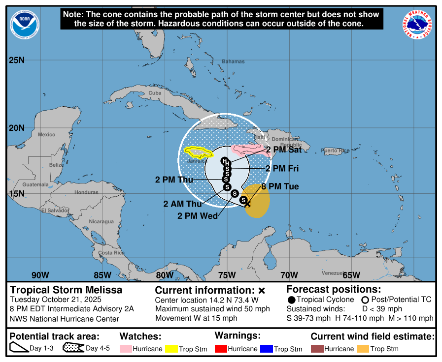
According to the latest advisory from the NHC, Tropical Storm Melissa, with maximum sustained winds of 50 mph, was located about 310 miles south-southwest of Port Au Prince, Haiti. Minimum central pressure is at 1003 mb or 29.62″.
For now, a Hurricane Watch is in effect for the southwestern peninsula of Haiti from the border with the Dominican Republic to Port-Au-Prince. A Tropical Storm Watch is in effect for all of Jamaica. A Hurricane Watch means that hurricane conditions are possible within the watch area. A watch is typically issued 48 hours before the anticipated first occurrence of tropical-storm-force winds, conditions that make outside preparations difficult or dangerous. A Tropical Storm Watch means that tropical storm conditions are possible within the watch area, generally within 48 hours.
“Interests elsewhere in Haiti, the Dominican Republic, and Cuba should monitor the progress of Melissa,” warns the NHC.
Melissa is moving toward the west near 15 mph. A decrease in forward speed and a gradual turn to the northwest and north is expected during the next few days. On the forecast track, Melissa is expected to approach Jamaica and the southwestern portion of Haiti later this week. Gradual strengthening is expected during the next few days and the NHC expects Melissa to reach hurricane strength by the weekend.
Where Melissa, as a hurricane, heads beyond this weekend isn’t yet known. The National Hurricane Center forecast calls for it to meander between Jamaica and Haiti. Some computer forecast guidance suggests the storm may head west, while others bring it to the east; some even bring it north into the Bahamas. It will likely take a few days of analysis to better understand Melissa’s future track.
