Portions of the Mid Atlantic are bracing for the likely impacts from a developing cyclone that’ll be named Ophelia; tropical storm force winds, flooding rains, tornadoes, and life-threatening storm surge will all be possible with this storm.
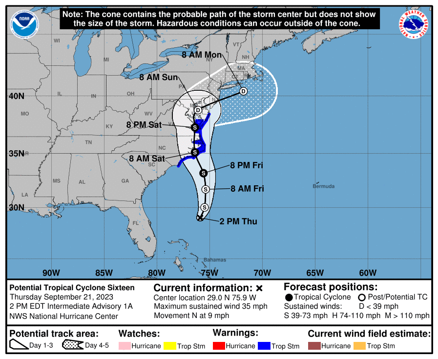
According to the National Hurricane Center (NHC) in Miami, Florida, a broad non-tropical area of low pressure has formed well east of the east coast of Florida this morning. Although this system is forecast to remain non-tropical during the next 12-24 hours, the dynamical model guidance indicates that it will likely acquire tropical characteristics late Friday and early Saturday as it approaches the coast of North Carolina. Although it is unclear as to whether the cyclone detaches from a front that is forecast to extend northeastward from the center, the guidance suggests a tropical-cyclone like core and structure when it nears the coast.
As a result, the National Hurricane Center has imitated advisories on what’s being called “Potential Tropical Cyclone Sixteen” now. Tropical Storm Warnings and Storm Surge Watches for portions of the coasts of North Carolina, Virginia and Maryland have been issued now and additional tropical watches and warnings could be issued north up the coast later today.
“There is the potential for life-threatening storm surge inundation from Surf City, North Carolina to Chincoteague, Virginia, the Pamlico and Albemarle Sounds, and the lower Chesapeake Bay,” the National Hurricane Center warns. “Residents in these areas should follow advice given by local
officials.”
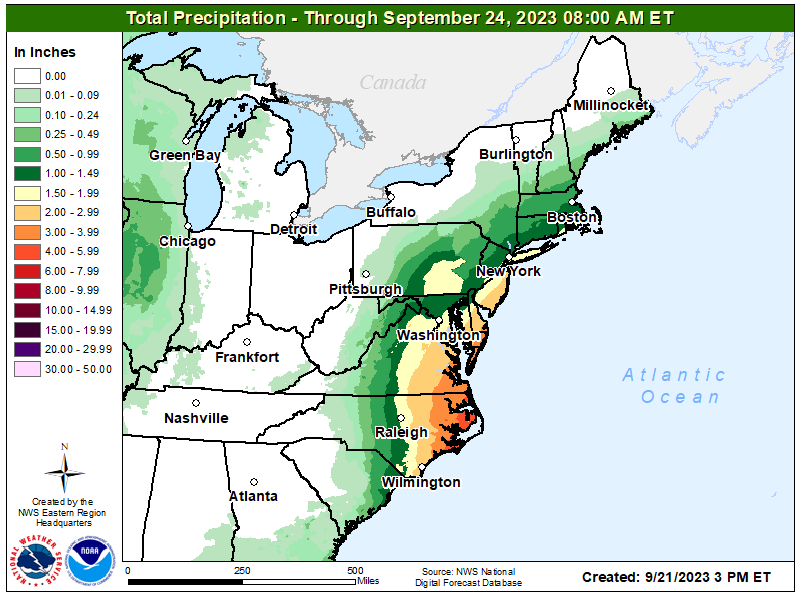
“Heavy rainfall from this system could produce localized urban and small stream flooding impacts across the eastern mid-Atlantic states from North Carolina to New Jersey Friday through Sunday,” the National Hurricane Center adds.
For now, Tropical Storm Warnings are in effect for Cape Fear, North Carolina to Fenwick Island, Delaware, Chesapeake Bay south of Smith Point, and the Albemarle and Pamlico Sounds. A Storm Surge Watch is in effect for Surf City, North Carolina to Chincoteague, Virginia, Chesapeake Bay south of Smith Point, and for the Albemarle and Pamlico Sounds. A Tropical Storm Warning means that tropical storm conditions are expected somewhere within the warning area within 36 hours.
A Storm Surge Watch means there is a possibility of life-threatening inundation, from rising water moving inland from the coastline, in the indicated locations during the next 48 hours.
As of the latest update from the NHC, the storm system was located about 355 miles southeast of Charleston, South Carolina and about 430 miles south of Cape Hatteras, North Carolina. Maximum sustained winds were at 35 mph while the storm moved slowly to the north at 9 mph. Minimum central pressure is at 1012 mb or 29.89″.
The system is forecast to continue to head north through early Friday and then slide north-northwest to north by late Friday and into the weekend. On the forecast track, the center of the cyclone is forecast to approach the coast of North Carolina within the warning area Friday night and early Saturday. Strengthening is expected during the next day or two, and the system is forecast to become a tropical storm as it approaches the coast of North Carolina. Regardless of whether the system become a tropical storm, the system is expected to bring tropical-storm conditions to portions of the southeast and mid-Atlantic coasts.
When the storm becomes a tropical storm, it will be named Ophelia.
As Ophelia moves into the Mid Atlantic, a potentially life-threatening storm surge, damaging winds, tornadoes, flooding rains, and rough surf will batter the region.
The combination of a dangerous storm surge and the tide will cause normally dry areas near the coast to be flooded by rising waters moving inland from the shoreline. If the peak surge occurs at the time of high tide, a 2-4′ storm surge is possible from Surf City, North Carolina to Chincoteague, Virginia, for the Chesapeake Bay south of Smith Point, and for the Albemarle and Pamlico Sounds. North, from Chincoteague, Virginia to Fenwick Island, Delaware, and south, from South Santee River, South Carolina to Surf City, North Carolina, a 1-3′ storm surge is possible. The deepest water will occur along the immediate coast near and to the north of the landfall location, where the surge will be accompanied by dangerous waves. Surge-related flooding depends on the relative timing of the surge and the tidal cycle, and can vary greatly over short distances.
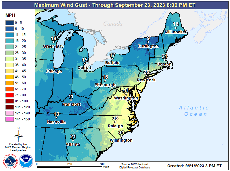
Tropical storm force wind conditions are expected to first reach the coast within the warning area in North Carolina on Friday, and spread northward Friday night and Saturday.
Landfalling tropical cyclones create tornadoes and tornadoes will be possible as this moves through the Mid Atlantic, with the greatest danger of tornadoes over southern New Jersey, southeastern Pennsylvania, all of Delaware, and eastern Maryland, Virginia, and North Carolina.
The system is forecast to produce 2-4″ of rain with localized amounts of 6″ possible across the eastern Mid-Atlantic states from North Carolina to New Jersey, Friday through Sunday. This rainfall may produce localized urban and small stream flooding impacts.
Swells generated by this system will be affecting much of the east coast of the United States through this weekend. These swells are likely to cause life-threatening surf and rip current conditions. As such, the National Weather Service warns that even experienced swimmers and surfers should avoid the ocean until the cyclone’s hazards have passed.
