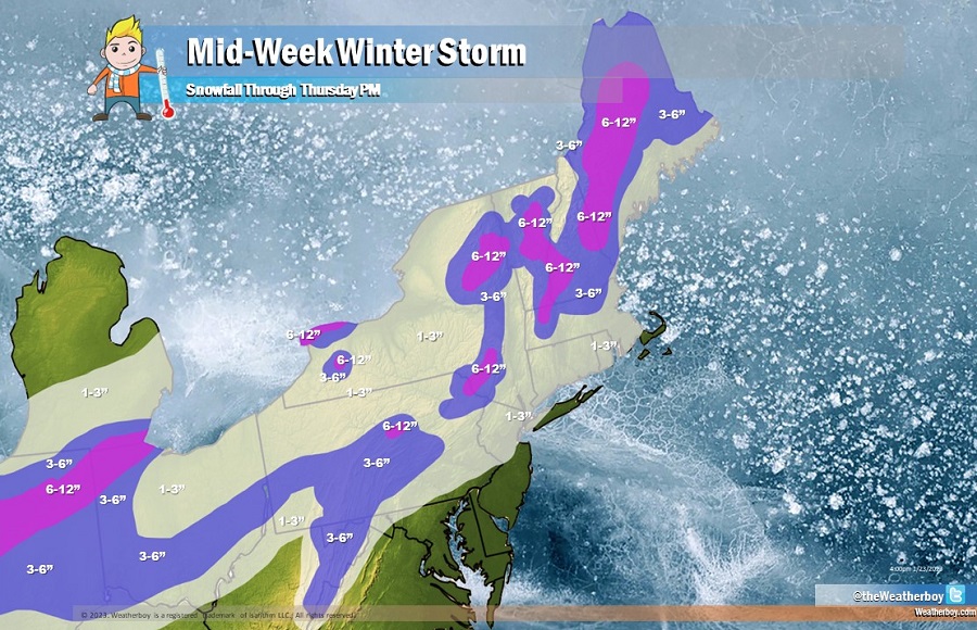
A mid-week winter storm is expected in the Northeast, although most accumulating snow will fall well north and west of the big cities along the I-95 corridor. The heaviest snow will fall across central and northern Indiana, northwest Ohio, and the higher terrain of New England away from the coast. Elsewhere, a widespread 1-3″ snowfall is expected, although light snow is expected to change over to plain rain in portions of eastern Pennsylvania, northern New Jersey, and southeast New England which could wash away any snow that does fall.
Low pressure will move up across Indiana and western Ohio before slowing and moving across Lake Erie. Meanwhile, a secondary area of low pressure will form closer to eastern Virginia and move up across New Jersey and Long Island Wednesday night. These atmospheric events will squeeze out precipitation across the northeast, starting as snow in colder areas but changing over to plain rain as milder air rides up the coastal plain. Accumulating snow will be confined to areas north and west of I-95, although a light coating is possible in/around Philadelphia, central New Jersey, and the New York City metro area before plain rain arrives to wash it away.
The snow could briefly fall heavy at times, producing several inches of snow across the higher terrain of New England, especially interior Maine. Up to 6-12″ of snow is possible there. But as you get closer to the coast even in New England, snow amounts will dwindle.
This storm system won’t have much time to intensify; as such, wind won’t be a major issue. There may be some Wind Advisory-criteria gusts met along the coastal regions, but they won’t last long and become too problematic.
As relatively warmer air slides up the coast, there’s also a chance for scattered thundershowers in southern New Jersey, Delaware, and eastern Maryland. While dangerous lightning is possible, storms aren’t expected to become severe.
