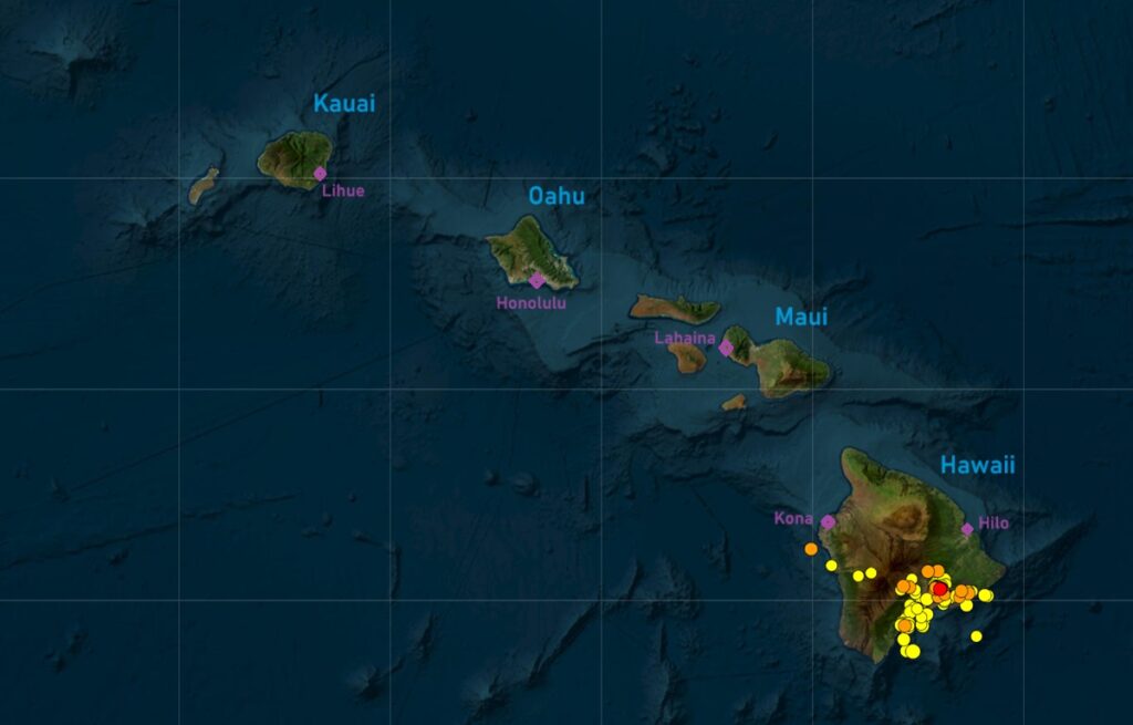
More than 850 earthquakes have rattled the Big Island of Hawaii over the last 30 days, with more than 300 in the last 48 hours. With most of the earthquakes centered around the Kilauea volcano, officials have decided to close portions of Hawaii Volcanoes National Park in an abundance of caution. The volcano is not erupting at this time, but that could change, according to USGS.
In an update released today, Hawaiian Volcano Observatory (HVO) from USGS said, ” The significant increase in seismicity beneath the upper East Rift Zone and caldera south of Halemaʻumaʻu that began in the early morning of April 27 is continuing and has intensified. ”
Earthquake activity had increased sharply just after midnight on April 27 beneath the upper East Rift Zone between Puhimau Crater and Hilina Pali road and beneath Kilauea caldera south of Halemaʻumaʻu. USGS reports that earthquakes are occurring at depths of 1-1.5 miles beneath the surface.
In addition to the surge in earthquake activity, Kilauea’s summit remains inflated. HVO scientists have been observing tiltmeter data to look for clues when the next eruption at the active volcano could occur. Tilt measurements have been used to monitor volcanoes in the United States since the founding of the Hawaiian Volcano Observatory in 1912. When magma accumulates beneath the ground, causing the surface above to inflate, the slope of adjacent areas will usually tilt away from the center of uplift. Conversely, if the ground deflates as a consequence of magma draining from a subsurface reservoir, the slope of adjacent areas will tilt toward the center of subsidence.
In their latest update, HVO says that overall ground deformation continues, with ongoing inflation of the summit and uplift south of the caldera. Tiltmeters near Uēkahuna and Sand Hill showed decreased rates of inflation and uplift on the evening of April 27 with the onset of a deflation-inflation (DI) event. The intense swarm of earthquakes recorded between 11 pm and midnight last night (April 28) coincided with increased inflation recorded on the Uēkahuna tiltmeter associated with the inflationary end of the DI event that began the previous day. Inflation at both tiltmeters returned to lower rates along with the seismicity just before midnight on April 28.

USGS scientists are also examining gas readings for clues of an eruption. Right now, sulfur dioxide (SO2) gas emission rates remain low. An SO2 emission rate of approximately 52 tonnes per day was recorded on April 23.
According to HVO, it is not possible at this time to know if this increase in activity will lead to an eruption in the near future or simply remain confined below ground. However, the gradual strengthening of seismic swarms suggests that an eruption in the summit region of Kilauea or beneath the upper East Rift Zone in the park is one potential outcome.
Due to that risk, the national park staff has closed-off some portions of the park.
“Safety is our main focus, and the uncertainty of where an eruption could break out increases risk,” said Chief Ranger Jack Corrao. “Elevated volcanic gases, dangerous lava activity, damaging earthquakes and lava-ignited wildfire are all potential hazards associated with an eruption.”
For now, park officials have closed Chain of Craters Road at Crater Rim Drive. Also closed is Hilina Pali Road to all and the nearby Kulanaokuaiki Campground is closed. Overnight camping has also been suspected for all coastal sites, Napau, and Pepeiao Cabin. The Ka’u Desert Trail is also closed beyond the Footprints Exhibit; the Maunaiki Trail is also closed.
Many popular areas in the park remain open, including Kīlauea Visitor Center, overlooks along Crater Rim Trail, Volcano House, Nāhuku lava tube, Chain of Craters Road and more.
Park officials report that the ongoing increased seismicity has not yet impacted traffic safety or any infrastructure projects at the Summit.