• Skip to primary navigation
  • Skip to main content
  • Skip to primary sidebar

Weatherboy

Weatherboy Weather News, Maps, RADAR, Satellite, and Forecasts.

  • Local
  • Earth Science News
  • RADAR
  • Current Warnings
  • Satellite
  • Current Maps
  • Forecast Maps
  • Video

More Snow Likely in Area Tuesday/Wednesday Impacted by Today’s Blizzard

by Weatherboy Team Meteorologist - February 23, 2026

More snow will move through the northeast tomorrow into Wednesday, as depictured by this short-duration/high-resolution computer forecast model, the HRRR. Image: tropicaltidbits.com

While the northeast digs out of the Blizzard of 2026, it appears Old Man Winter will be making another visit, with light snow likely Tuesday into Wednesday in the areas impacted by today’s storm. However, this next system will be weak, starved for moisture, and will lack much cold air to work with.

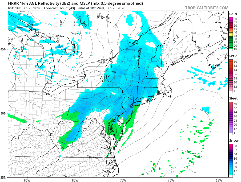
A clipper system will approach the northeast from the west Tuesday night. Precipitation will mostly be snow throughout the region, but the\ highest snowfall totals will be across the southern Poconos, far northwest New Jersey, southeastern New York State, Connecticut, Rhode Island, and Massachussetts.  Farther south, precipitation amounts will be lighter, so not as much snow will accumulate. In addition, rain should mix with the snow, and eventually change to rain Wednesday morning before ending south of I-78 in Pennsylvania and New Jersey.

Overall, about 1-3″ of snow is possible north and west of the Fall Line, with 3-4 inches possible in the southern Poconos, southeaster Upstate New York, Connecticut, Rhode Island, and Massachussetts.  Less than an inch of snow is expected to  accumulate elsewhere.


The National Weather Service says that as this system lifts to the northeast, winds will  take on a southwest flow behind this departing system. With warm air advection underway, highs should warm up on Wednesday
under clearing skies, allowing for at least some of the snowpack from the Blizzard of 2026 to start melting.

Primary Sidebar

Sponsored Ad

Search

Latest News

  • Morning Quake Rattles New York
  • Another Catastrophe in Hawaii; Epic Flooding, Heavy Snow Returns; Dam Failure Imminent; Evacuations Ordered
  • Overnight Earthquake Rattles Alabama
  • Today Wraps Up Winter; Spring 2026 Arrives Tomorrow
  • Earthquake Rattles South Carolina Near Critical Dam
  • Geomagnetic Storm Watch Issued for Earth for March 19-21
  • Extreme Heat Coming to Western U.S.
  • Meteor Creates Loud Boom in Eastern United States
About | Careers | Contact | Contests
Terms | Privacy | Ad Choices
Weatherboy is a (R) Registered Trademark of isarithm LLC, All Rights Reserved.
All content herein is Copyright by Isarithm LLC 1997-2022

Insert/edit link

Enter the destination URL

Or link to existing content

    No search term specified. Showing recent items. Search or use up and down arrow keys to select an item.