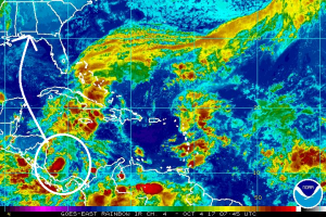
After a brief respite that saw no named tropical cyclones in the Atlantic Hurricane Basin after a busy period that included Harvey, Irma, Kate, Jose, and Lee, it looks like activity is returning with Nate on the way. The National Hurricane Center is monitoring an area for potential tropical cyclone development in the Caribbean Sea, which if becomes a named tropical cyclone, would be called Nate.
According to the National Hurricane Center, showers and thunderstorms associated with the broad area of low pressure located over the southwestern Caribbean Sea continue to show signs of organization. Environmental conditions are forecast to steadily become more conducive for development, and this system is expected to become a tropical depression within the next couple of days. The large disturbance should move slowly northwestward across or near the eastern portions of Nicaragua and Honduras, move into the northwestern Caribbean Sea on Thursday, and emerge over the southern Gulf of Mexico by the weekend. Interests in Nicaragua, Honduras, Belize, and the Yucatan peninsula should monitor the progress of this system over the next few days. It is still too soon to say with certainty where this system could go beyond there, but most global forecast guidance suggests this system will cross the central Gulf coast of the US.
An Air Force Reserve reconnaissance aircraft is scheduled to investigate the disturbance this afternoon, if necessary. Regardless of development, this system will likely produce heavy rains over portions of Central America during the next few days.
The National Hurricane Center believes there’s a 70% that a tropical cyclone will form here over the next 48 hours and has a high 80% chance of it doing so within the next five days.