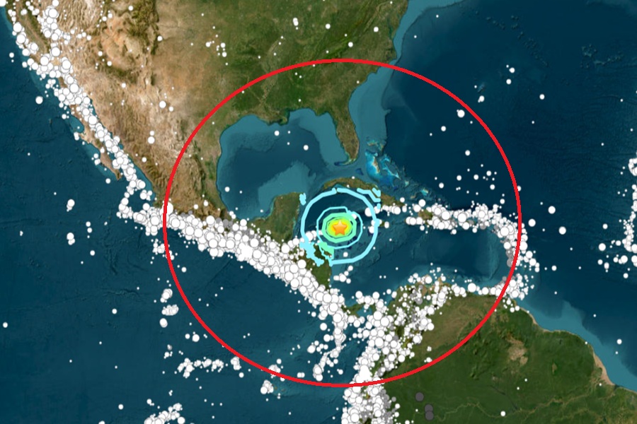
A powerful 7.6 earthquake struck in the Caribbean Sea north of Honduras this evening at 8:23 pm ET, triggering numerous tsunami alerts. According to USGS, a magnitude 7.6 earthquake with an epicenter of 10 km deep struck the Caribbean Sea roughly 130 miles south-southwest of George Town on the Cayman Islands and roughly 250 miles north and east of the Honduras / Nicaragua border. Numerous agencies have issued tsunami bulletins including the National Weather Service’s Pacific Tsunami Warning Center in Honolulu, Hawaii and the National Tsunami Warning Center in Palmer, Alaska.
According to the National Weather Service, tsunami waves have been recorded in portions of the Caribbean.
Initially, a Tsunami Advisory had been issued for Puerto Rico and the U.S. Virgin Islands. “Based on all available data, there is a tsunami threat to Puerto Rico and the Virgin Islands of sea level fluctuations and strong ocean currents that could be a hazard along coasts, beaches, in harbors, and in coastal waters.” However, minutes later, an updated bulletin was issued stating there is no longer a tsunami threat to Puerto Rico and the U.S. Virgin Islands.
Unfortunately, that isn’t the case closer to the epicenter of the powerful earthquake where tsunami is observed. “Based on all available data, hazardous tsunami waves are forecast for some coats,” warns the National Weather Service’s Pacific Tsunami Warning Center in Honolulu which is also responsible for issuing advisories for the Caribbean, the Gulf of America coast, and the U.S. East Coast. They added, “Based on all available data, hazardous tsunami waves are forecast for some coasts.”
Based on the National Weather Service’s tsunami threat forecast, tsunami waves reaching 3-9 feet above the tide level are possible along some coasts of Cuba. Tsunami waves reaching 0.3 – 1 meters above the tide level are also possible for some coasts of the Cayman Islands and Honduras.
“Actual amplitudes at the coast may vary from forecast amplitudes due to uncertainties in the forecast and local features.In particular, maximum tsunami amplitudes on atolls or small islands and at locations with fringing or barrier reeds will likely be much smaller than the forecast indicates,” the Tsunami Warning Center bulletin says.
“Persons located in threatened coastal areas should stay alert for information and follow instructions from National and Local authorities,
the National Weather Service advises.
A tsunami is a series of waves. The time between wave crests can vary from 5 minutes to an hour. The hazard may persist for many hours or longer after the initial wave. Impacts can vary significantly from one section of coast to the next due to local bathymetry and the shape and elevation of the shoreline. Impacts can also vary depending upon the state of the tide at the time of the maximum tsunami waves.”
The Tsunami Warning Center warns, “Persons caught in the water of a tsunami may drown, be crushed by debris in the water, or be swept out to sea.”
Further away from the epicenter, the Tsunami Warning Center says there is no current threat of tsunami to the U.S. Gulf of America coast or the U.S. East Coast.
