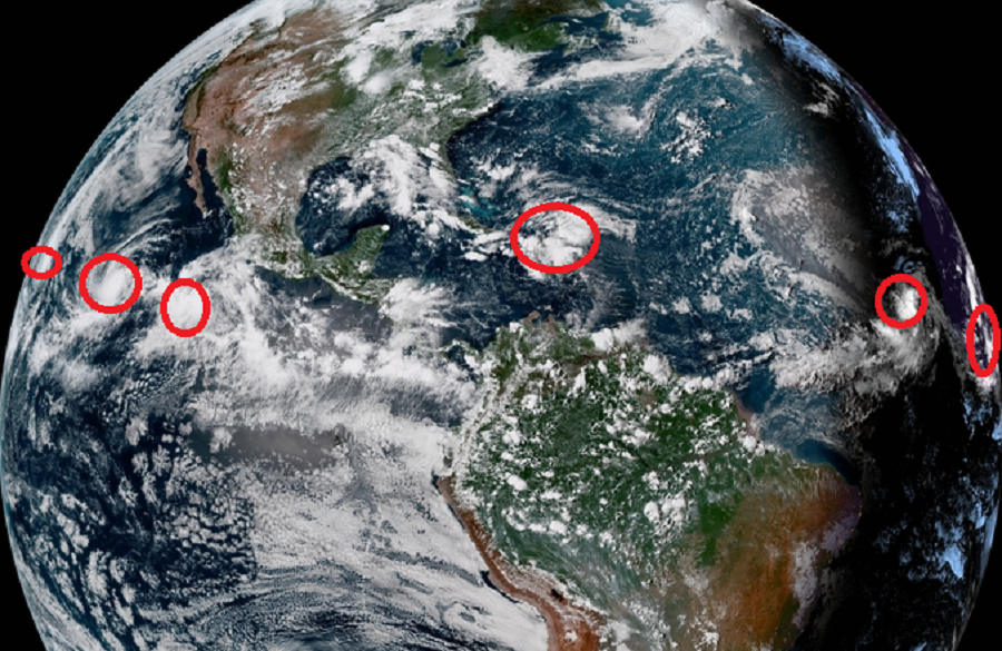
The tropics are very active in the Eastern Pacific Hurricane Basin and are about to become active in the Atlantic Hurricane Basin too. While no storms are expected to impact the U.S. this weekend, residents of the U.S. East and Gulf coasts and Hawaii should closely monitor the tropics as we enter September.
In the Pacific, Miriam entered the Central Pacific Hurricane Basin yesterday while Norman continues to spin about in the Eastern Pacific; it is also likely Olivia will form soon. While the Atlantic has been relatively quiet in the last several weeks, the same hasn’t been true in the Pacific where an active hurricane season continues. While Hawaii was impacted by Hurricane Lane, direct impacts aren’t yet expected by Miriam or Norman. However, people in Hawaii should continue to track these storms and make sure their hurricane supplies are re-stocked in Lane’s wake.

In the latest advisory from the Central Pacific Hurricane Center, the center of Hurricane Miriam was located near latitude 18.3 North, longitude 141.2 West. Miriam is moving toward the north near 10 mph. This general motion is expected to continue through tonight. A turn toward the northwest with an increase in forward speed is expected Saturday through Sunday. Maximum sustained winds are near 90 mph with higher gusts.. Rapid weakening is expected to begin later today and continue through Sunday. Miriam is expected to become a post-tropical remnant low Sunday or Sunday night and pass harmlessly far from Hawaii. Today, hurricane-force winds extend outward up to 25 miles from the center and tropical-storm-force winds extend outward up to 105 miles. The estimated minimum central pressure is 978 mb or 28.88 inches.
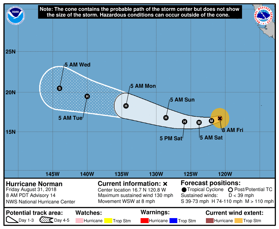
In the latest advisory from the National Hurricane Center, Hurricane Norman continues to travel over the open waters of the Pacific. Once it passes 140W, the Central Pacific Hurricane Center will issue advisories for it. For now, the eye of Hurricane Norman was located near latitude 16.7 North, longitude 120.8 West. Norman is moving toward the west-southwest near 8 mph. A turn toward the west and west-northwest with an increase in forward speed is expected over the weekend and into next week. Maximum sustained winds have decreased to near 130 mph with higher gusts. Norman is a category 4 hurricane on the Saffir-Simpson Hurricane Wind Scale. Gradual weakening is forecast, but Norman is expected to remain a powerful hurricane through the
early part of next week. Hurricane-force winds extend outward up to 25 miles from the center and tropical-storm-force winds extend outward up to 90 miles. The estimated minimum central pressure is 950 mb or 28.06 inches. Norman will be traveling over waters recently disturbed by Hurricane Miriam; it is likely the storm will weaken as it heads west. The weather pattern in place near Hawaii should keep Norman away from the islands. However, people there should continue to track Norman’s future progress should the system head further south than expected. Any further south trend could threaten the islands in the extended range.
A new disturbance picking up strength in the Pacific could become Olivia. Showers and thunderstorms, associated with a low pressure system located several hundred miles south-southwest of Manzanillo, Mexico continue to show signs of organization. Additional development is expected and a tropical depression is likely to form later today or on Saturday while the system moves generally west-northwestward, away from the coast of Mexico. Computer forecast guidance suggests this storm will develop into a tropical storm and eventually a hurricane; when it does so, it would be named Olivia. It is too soon to say with certainty whether Olivia would impact Hawaii; if it were, it wouldn’t happen prior to September 7.
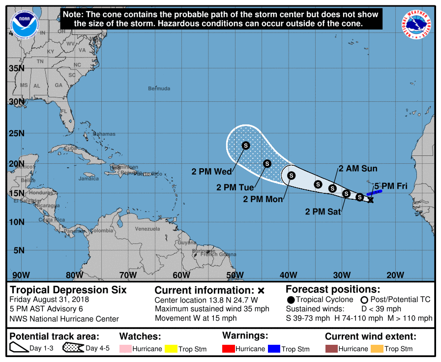
The Atlantic Ocean now has its sixth tropical depression of the 2018 Atlantic Hurricane Season. The center of newly formed Tropical Depression Six was located near latitude 13.8 North, longitude 24.7 West. The depression is moving toward the west near 15 mph, and this track with a gradual turn to the west-northwest is expected for the next two or three days. On the forecast track, the depression will be passing just south of the Cabo Verde Islands tonight and Saturday. The depression should then be moving over the open eastern Atlantic on Sunday and Monday. Maximum sustained winds are near 35 mph with higher gusts. Strengthening is forecast, and the depression is expected to become a tropical storm tonight or Saturday; when it does so, it will be named Florence. The estimated minimum central pressure based on observations from the Cabo Verde Islands is 1004 mb or 29.65 inches.
With Florence expected to form, a Tropical Storm Warning has been issued for the Cabo Verde Islands of Santiago, Fogo, and Brava. A Tropical Storm Warning means that tropical storm conditions are expected somewhere within the warning area, in this case within the next 6 to 12 hours.
Lastly, another system closer to the United States is getting attention just north of the Dominican Republic. Disorganized cloudiness and showers extending from Hispaniola northeastward to the adjacent Atlantic are associated with a tropical wave interacting with an upper-level trough. This activity is forecast to spread westward to west-northwestward enhancing the rainfall across portions of Hispaniola, the Bahamas, the Turks and Caicos Islands, and Florida into early next week. Strong upper-level winds will prevent any development of this system during the next 2 to 3 days, but environmental conditions could become less hostile when the system reaches the eastern Gulf of Mexico during the early to middle part of next week. As such, those around the Gulf Coast and Florida should keep an eye on this system this weekend and review Hurricane Action Plans. Should development occur in the Gulf of Mexico next week, acting on the Hurricane Action Plans may become necessary.
