Still in an active weather pattern, it appears another round of severe weather will be marching across the country in the coming days of this new week. As was the case over the last few weeks, severe weather will start in the Central States and slide east, eventually bringing the threat of severe thunderstorms and tornadoes to portions of the Midwest and eventually the Southeast and Mid Atlantic once again.
A storm system that’ll organize over the midwest later tomorrow will be to blame for this next severe weather outbreak. Scattered to numerous severe thunderstorms are expected later Tuesday across parts of the southern and central Plains into the lower and mid Mississippi Valley and Midwest. Scattered large to very large hail, numerous severe wind gusts, and a few tornadoes may occur.
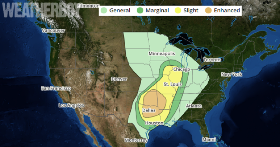
According to the National Weather Service’s Storm Prediction Center, a shortwave trough will dig southeastward from the northern Rockies and Plains to the Mississippi Valley on Tuesday. As it does so, a surface low is forecast to develop eastward across the Upper Midwest to southern Wisconsin by Tuesday evening. A low-level moisture return will occur in earnest across the southern Plains into parts of the ArkLaTex, with mid 60s to low 70s surface dewpoints becoming common. A surface dryline will extend southward from a thermal low across the southern High Plains, and steep mid-level lapse rates will be present over much of the warm sector. With ample diurnal heating expected, moderate to very strong instability appears likely to develop by peak afternoon heating. Convection will quickly form and then explosively strengthen along a southeastward-moving cold front across southern Kansas and northern Oklahoma by late Tuesday afternoon.
From Wednesday on, the severe weather action is forecast to shift east, with severe weather projected to impact portions of the Ohio Valley and southeast Wednesday into Thursday. A line of heavy rain showers and strong thunderstorms should finally reach the Atlantic coast by late Thursday or early Friday, bringing an end to this week’s severe weather outbreak.
