• Skip to primary navigation
  • Skip to main content
  • Skip to primary sidebar

Weatherboy

Weatherboy Weather News, Maps, RADAR, Satellite, and Forecasts.

  • Local
  • Earth Science News
  • RADAR
  • Current Warnings
  • Satellite
  • Current Maps
  • Forecast Maps
  • Video

NJ Evacuation Drill Set for June 8

by Weatherboy Team Meteorologist - June 7, 2017

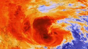
Hurricane Sandy impacted the Garden State in 2012, triggering mass evacuations from the coast. A drill set for June 8 will help prepare authorities for future storms like Sandy. Image: NOAA

An evacuation drill is set for Thursday, June 8, in New Jersey to practice and refine response in the event of a major hurricane. The New Jersey Department of Transportation (NJDOT), New Jersey State Police (NJSP), the New Jersey Turnpike Authority (NJTA), and the South Jersey Transportation Authority (SJTA) are working together to conduct the emergency evacuation exercise.


No roads will be closed, however motorists should expect an increased police and work crew presence on key shore routes. Crews will be staging cones, traffic barrels, and electronic message display boards in designated locations along the side of the highways, but will not actually deploy them into the traffic.  With crews staging these objects, motorists should drive with care, especially around the workers participating in the exercise.

The main effort being tested in this drill is to set-up a contra flow on highways that serve as evacuation routes for the Jersey Shore. A contra flow is when traffic is reversed on a section of roadway so that travel can occur in the opposite of the usual direction.


Roads participating in Thursday’s drill include:

  • Atlantic City Expressway (entire length from Atlantic City to Washington Township)
  • Garden State Parkway (mile post 0 in Lower Township to mile post 38 in Egg Harbor)
  • I-195 (mile post 6 in Robbinsville to about mile post 34 in Wall)
  • Route 72 (mile post 13.8 in Barnegat to approximately mile post 29 in Ship Bottom)
  • Route 47 (mile post 16 to 21 in Dennis, and approximately mile post 32 to 35 in Maurice River)
  • Route 347 (mile post 0 in Dennis to about mile post 9 in Maurice River)

Primary Sidebar

Sponsored Ad

Search

Latest News

  • Strong, Damaging Earthquake Strikes Hawaii
  • NOAA Releases 2026 Hurricane Season Outlooks; Bad News for Hawaii, Better News for East Coast
  • USGS Monitoring Surge of Atlantic Earthquakes; 240 in Last 30 Days Near Puerto Rico
  • Severe Storms Bring Gusty Winds to Pennsylvania, New Jersey, New York
  • Afternoon Earthquake Rattles New Jersey
  • USGS Predicts Volcano Will Erupt May 22-25
  • No Tsunami Expected Along U.S. East & Gulf Coasts from Strong Atlantic Earthquake
  • National Weather Service Looking to Fill Hundreds of Meteorology Jobs
About | Careers | Contact | Contests
Terms | Privacy | Ad Choices
Weatherboy is a (R) Registered Trademark of isarithm LLC, All Rights Reserved.
All content herein is Copyright by Isarithm LLC 1997-2022

Insert/edit link

Enter the destination URL

Or link to existing content

    No search term specified. Showing recent items. Search or use up and down arrow keys to select an item.