• Skip to primary navigation
  • Skip to main content
  • Skip to primary sidebar

Weatherboy

Weatherboy Weather News, Maps, RADAR, Satellite, and Forecasts.

  • Local
  • Earth Science News
  • RADAR
  • Current Warnings
  • Satellite
  • Current Maps
  • Forecast Maps
  • Video

Odds Grow for East Coast Cyclone Threat

by Weatherboy Team Meteorologist - September 14, 2024

Latest satellite image from the GOES-East weather satellite shows an area of clouds, showers, and storms inside a red circle being closely monitored by the National Hurricane Center for any signs of development.  Image: NHC
Latest satellite image from the GOES-East weather satellite shows an area of clouds, showers, and storms inside a red circle being closely monitored by the National Hurricane Center for any signs of development. Image: NHC

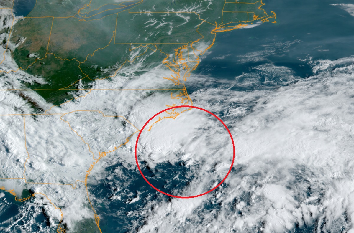
Odds are growing that a tropical or subtropical cyclone will form along the East Coast in the coming days, perhaps bringing wind-lashed heavy rains to portions of the Mid Atlantic. According to the latest Tropical Outlook from the National Hurricane Center (NHC), the odds of some kind of cyclone formation has increased to 30% over the next 48 hours and 50% over the next 7 days, an increase from yesterday’s outlook.

A simulated satellite view for Monday afternoon based on GFS Computer Forecast Data shows a developing system along the East Coast that is forecast to move north with time. Image: tropicaltidbits.com

According to that Tropical Outlook, a non-tropical area of low pressure is expected to form this weekend along a frontal boundary a few hundred miles off the southeastern U.S. coastline. The NHC says that this system could gradually acquire subtropical or tropical characteristics thereafter over the warm waters of the Gulf Stream which runs up/down the U.S. east coast off-shore. With development possible, the NHC says that a subtropical or tropical depression or storm could form early next week while the system moves generally northwestward toward the coast.

Even if a subtropical or tropical cyclone doesn’t develop, portions of the Mid Atlantic, especially North Carolina and Virginia, could see soaking rains from it in the coming days.

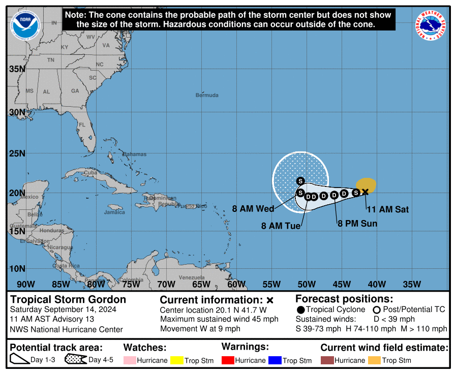
Meanwhile, Tropical Storm Gordon continues to spin about over the open waters of the Atlantic and is not a concern to any land mass.  According to the NHC, the weak tropical storm is expected to weaken into a tropical depression in the coming days but is expected to re-intensify back into a tropical storm just a few days later. Even so, it will still be of no threat to land for at least the next 7 days.

Latest forecast track for Gordon.  Image: NHC
Latest forecast track for Gordon. Image: NHC 

Primary Sidebar

Sponsored Ad

Search

Latest News

  • Hurricane Season Wraps Up Without Any U.S. Landfalls
  • NASA Releases Very Blurry and Pixelated Images of 3I/Atlas, Fueling More Alien Spacecraft Talk
  • Shock Update: NASA Confirms the Earth Now Has TWO Moons
  • Strong Earthquake Strikes Venezuela Coast; No U.S. East Coast Tsunami Threat
  • Winter Storm to Bring 4″+ Snow to Hawaii Today
  • NASA to Hold Special Media Event Wednesday to Discuss Interstellar Mystery Object 3I/Atlas
  • Overnight Earthquake Rattles Kentucky Southeast of Cincinnati, Ohio
  • Comet C/2025 K1 (Atlas) Splits Up While Interstellar Object 3I/Atlas Continues to Puzzle Scientists
About | Careers | Contact | Contests
Terms | Privacy | Ad Choices
Weatherboy is a (R) Registered Trademark of isarithm LLC, All Rights Reserved.
All content herein is Copyright by Isarithm LLC 1997-2022

Insert/edit link

Enter the destination URL

Or link to existing content

    No search term specified. Showing recent items. Search or use up and down arrow keys to select an item.