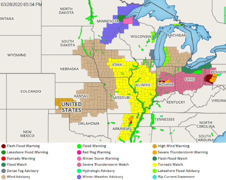
A violent weather outbreak continues this evening, with the National Weather Service issuing a rare “Particularly Dangerous Situation Tornado Watch” among many watches and warnings that are up. The National Weather Service’s Storm Prediction Center (SPC) warns that several tornadoes and a few intense tornadoes are likely; scattered large hail and isolated very large hail with a diameter of 2.5″ or greater are possible too. Beyond flash-flooding rains, destructive wind gusts of 50-70 mph or more are also expected.
Thunderstorms are continuing to increase in strength and number at this time, with several intense supercell storms expected to evolve too.
A “Particularly Dangerous Situation” Tornado Watch is issued when there is a higher than normal risk of multiple strong to violent tornadoes, especially those that are predicted to be long-track in nature, with path lengths of more than 20 miles. Beyond damage consistent with high-end EF4 or EF5 tornadoes, there are also threats from significant wind and hail damage. This enhanced wording in a Tornado Watch is meant to alert the public of the potential for very life-threatening severe weather. While there are no set criteria for a Particularly Dangerous Situation watch to be issued, they are usually issued when the potential exists for a major tornado outbreak.
While a large area is under a Tornado Watch now, the Particularly Dangerous Situation Tornado Watch area is approximately along and around 110 statute miles either side of a line from 35 miles north northwest of Cedar Rapids, Iowa to 70 miles south southeast of Quincy, Illinois. Standard Tornado Watches are up to the south into Arkansas.
In addition to the Tornado Watches, the National Weather Service has also expanded Severe Thunderstorm Watches east into Indiana, Ohio, and Pennsylvania.
Within these watches, warnings exist, highlighting the fact that tornadoes are touching down or severe thunderstorms are impacting communities in the watch areas.
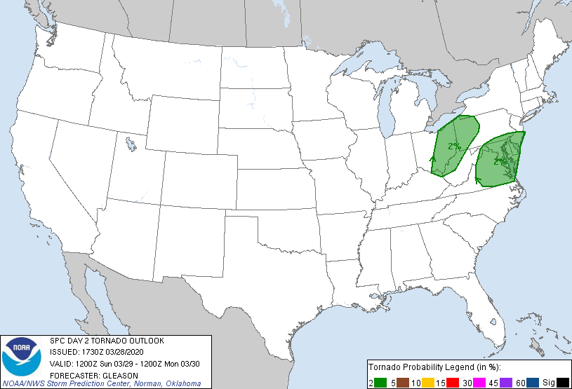
The SPC expects more severe weather tomorrow to shift east into portions of Ohio, Pennsylvania, New Jersey, Delaware, Maryland, and Virginia. While there will be a threat of tornadoes tomorrow too, they aren’t expected to be as violent as the ones occurring today.
With many dealing with the COVID-19 Pandemic in various states of quarantine, shelter-in-place, or no-travel orders, it is imperative that people in severe weather risk areas know what they’d do if severe weather struck before it actually does. Places safe from COVID-19 may not be safe from violent weather like tornadic thunderstorms. People need to plan out how to contain the spread of disease and risk contamination while dealing with the risks of severe weather. Ideally, those plans should be flushed out before the severe weather arrives.
