After a weekend that brought record high temperatures to portions of the eastern United States, it appears a shift in the weather pattern could produce a significant winter storm next weekend. A series of low pressure systems marching across the country this week will bring more rain showers to the eastern U.S. in the coming days; however, things should be a bit different come Friday as colder air finally slides down the east coast for the first time this month.
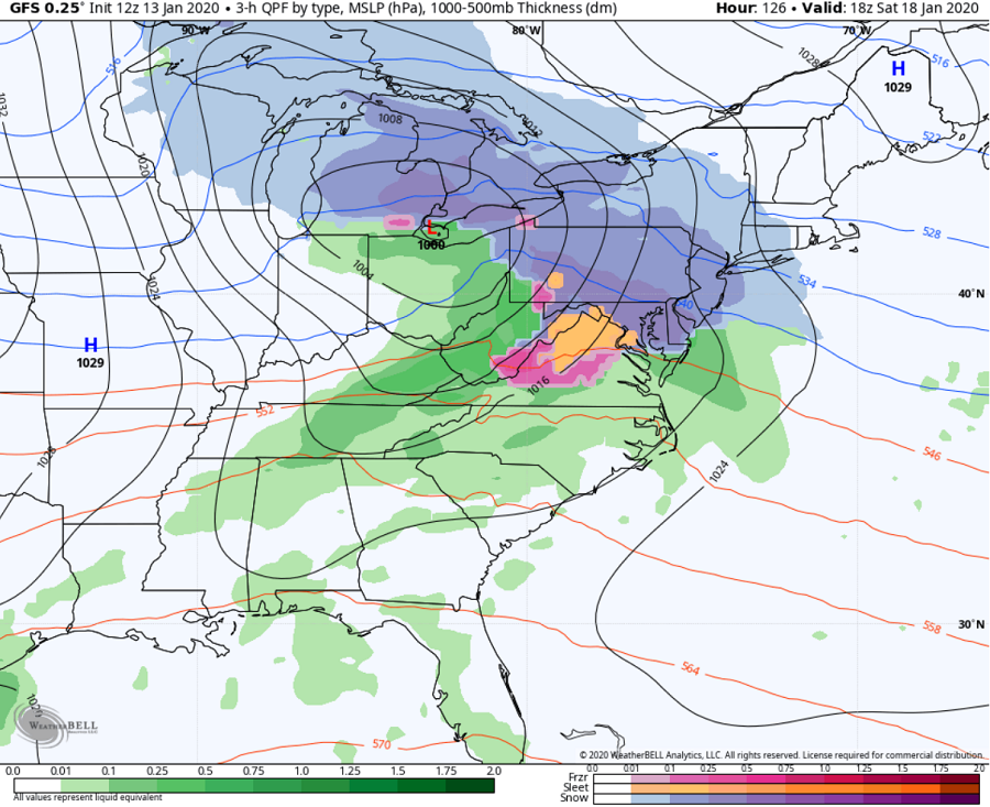
During the first half of next weekend, a potent area of low pressure will move through the northeast. The parent low should remain north over the Great Lakes region into New England, but secondary cyclogenesis should occur off the New York Coast as the parent moves through Saturday night into Sunday. With cold air in place, significant snow is possible for portions of the I-95 corridor from Washington, DC north to Boston. Places like Philadelphia and New York City could see the heaviest snowfall of the young 2019-2020 winter season. However, depending where that secondary cyclogenesis occurs, it appears mild air will surge up the coastal plain changing snow to sleet and freezing rain and eventually plain rain. Exactly how far north that changeover goes isn’t yet locked-down; recent computer forecast guidance has suggested the changeover area won’t extend north of New York City, but that could change north or south. By later Sunday afternoon, the system should exit the region, with drier, colder, and windy conditions arriving from the northwest.

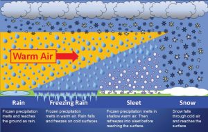
The snow from this event is considered a classic “overrunning event.” Following a cold frontal passage expected Wednesday night in the east, the low-level air mass is forecast to be cold and very dry. As precipitation arrives later Friday, it’ll be rising up and over the cold air at the surface. Because the air is so dry, a wet bulb effect will occur as precipitation begins to fall in the dry air mass, driving temperatures down. With moisture overrunning the cold air, snow will break-out across a wide area of the Mid Atlantic. This type of set-up will also result in a slower warm-up at the surface during Saturday, which would prolong the period of snow especially across the northern Mid Atlantic area. With high pressure sitting over portions of eastern Canada and New England, snow should be able to accumulate at the start of the storm. However, with the primary surface low tracking across the Great Lakes and then to New England, milder air will eventually wash-out the low level cold air in place, changing the snow over to non-snow precipitation types depending on the depth of the cold layer. The area that evolves from snow to non-snow will be dependent on how quickly and how strong that secondary low can develop off the coast. For now, it is still too early to know where the transition from snow to non-snow will occur; for now, based on climatology, it is most likely that this transition will eventually reach and extend beyond the I-95 corridor throughout southeastern New England, but confidence is low on that point for now.
Based on the forecast guidance today, people from Washington, DC to Boston and places north and west should prepare for some snow as early as late Friday into early Saturday. Depending on what happens with that secondary low, the snow will likely change to sleet, freezing rain, and plain rain from south to north on Saturday into Saturday night. Several inches of snow could fall before a changeover occurs, including in both Philadelphia and New York City. Climatology suggests these areas will change over to some plain rain before the system exits completely on Sunday, cutting down on snowfall accumulation amounts in the I-95 corridor. While precipitation should change to rain there, it should stay primarily all-snow across the higher terrain of New England, producing more welcome snow to the ski resorts there.