• Skip to primary navigation
  • Skip to main content
  • Skip to primary sidebar

Weatherboy

Weatherboy Weather News, Maps, RADAR, Satellite, and Forecasts.

  • Local
  • Earth Science News
  • RADAR
  • Current Warnings
  • Satellite
  • Current Maps
  • Forecast Maps
  • Video

PM Severe Storms, Tornadoes Expected around NYC Metro Today

by Weatherboy Team Meteorologist - August 27, 2020

The greatest risk of severe winds from today's storms is in the green area over southern Upstate New York, northeastern Pennsylvania, northern New Jersey, the metro New York City area, Long Island, and most of Connecticut. The broader area in light blue could also see severe thunderstorms with wind damage. Isolated tornadoes are likely too. Image: NWS
The greatest risk of severe winds from today’s storms is in the green area over southern Upstate New York, northeastern Pennsylvania, northern New Jersey, the metro New York City area, Long Island, and most of Connecticut. The broader area in light blue could also see severe thunderstorms with wind damage. Isolated tornadoes are likely too. Image: NWS


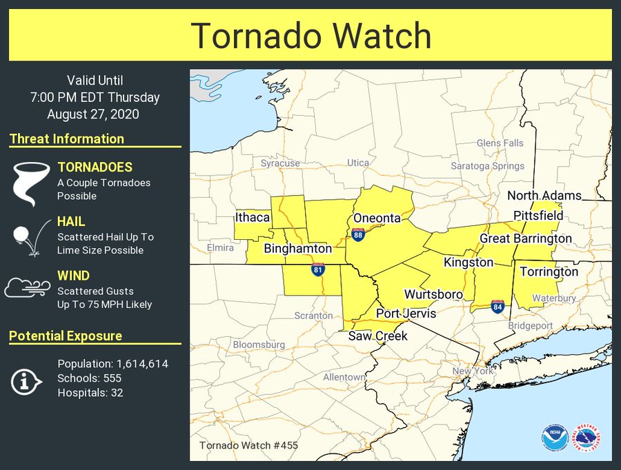
A robust disturbance is moving through the northeast today, setting the stage for severe to potentially violent thunderstorms across New York State, interior southern New England, and the New York City metro area. Due to this threat, the National Weather Service has already issued one Tornado Watch for the area and more watches and warnings are expected to be issued this afternoon.

This Tornado Watch is among many watches and warnings expected today for severe weather. Image: NWS

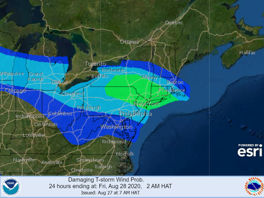
According to the National Weather Service’s Storm Prediction Center, a few tornadoes along with significant severe wind and hail will be possible in the Northeast through this evening.  Scattered thunderstorms continue to develop in a roughly west/east-oriented corridor across southern New York, spreading into southern New England with time.  Data captured by weather balloons, aircraft, and satellite show an atmosphere ripe with energy; a very strong upper level flow, high dewpoints, and significant instability are making conditions favorable for splitting supercells. These cells have the potential to create golf ball to tennis ball sized hail and several tornadoes.  Several fast-moving clusters of storms can also move through the region, setting the stage for damaging straight-line winds. The greatest threat of wind damage is over northeastern New Jersey, the New York City metro area, and Long Island.


The severe weather threat will diminish this evening. However, this region will begin to feel the impacts of the remnants of Hurricane Laura beginning later tomorrow.

Primary Sidebar

Sponsored Ad

Search

Latest News

  • 300+ Earthquakes Rock Caribbean, Still No U.S. East Coast Tsunami Threat
  • Atlantic Hurricane Basin Quiets with 4 Weeks of Season To Go
  • Quake Rattles Heart of New Madrid Seismic Zone in Missouri
  • Halloween Earthquake Rattles Alabama
  • Hurricane Melissa Moves Away from Bermuda; Expected to Become Extratropical Today
  • Potent Storm to Impact New Jersey, Pennsylvania, Delaware, and New York
  • Ongoing Strong Caribbean Earthquakes Serve as Reminder to East Coast Tsunami Threat
  • MELISSA MAKES LANDFALL AS ONE OF STRONGEST ATLANTIC HURRICANES EVER
About | Careers | Contact | Contests
Terms | Privacy | Ad Choices
Weatherboy is a (R) Registered Trademark of isarithm LLC, All Rights Reserved.
All content herein is Copyright by Isarithm LLC 1997-2022

Insert/edit link

Enter the destination URL

Or link to existing content

    No search term specified. Showing recent items. Search or use up and down arrow keys to select an item.