A potent nor’easter is forecast to impact portions of the Mid Atlantic and Northeast this week, dropping upwards of 2 feet of snow in locations. Beyond heavy snow, this storm will also produce damaging winds, coastal flooding, and heavy rain. And in between the snow and rain areas, an icy mix of sleet and freezing rain will mix with the snow and rain at times before precipitation ends as plain snow in the mix area.
A strong area of low pressure will strengthen off of the Mid Atlantic coast Wednesday into Thursday, dumping heavy precipitation onto portions of the eastern U.S. while whipping up winds and waves. Winds could gust 30-50 mph at the coast and up to 30 mph near the I-95 cities; such winds could create electrical interruptions, especially across New Jersey and Delaware. Coastal flooding will become a problem late Wednesday, especially in areas prone for coastal flooding in Delaware, New Jersey, and New York. With strong winds and rough surf, coastal erosion is likely.
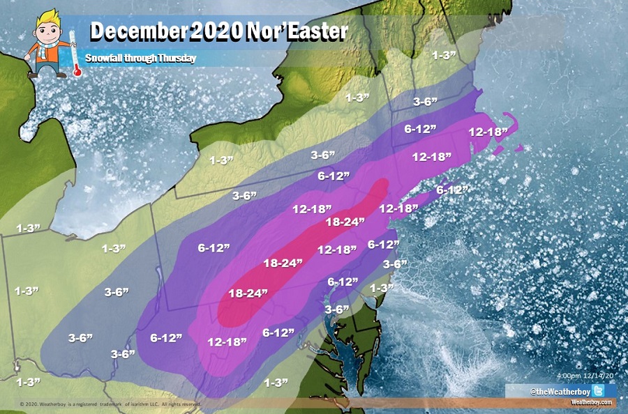
The heaviest snow will fall across portions of central Pennsylvania into northern New Jersey; here 18-24″ of snow is expected. A broad area of 12-18″ is expected from just north of the Philadelphia metro area into northern New Jersey, the New York City metro area, western Long Island, southern New England, and Boston’s southern suburbs. Because the storm is moving more east-northeast than northeast, there will be a sharp cut-off on the northern side of the storm, with just light 1-3″ amounts expected over portions of Upstate New York, southern New Hampshire and Vermont, and extreme southern Maine.
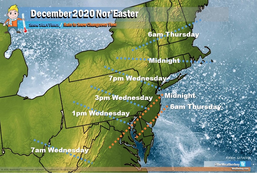
It appears enough warm air will enter the system to keep snow amounts lower on the south side of the storm near and south of the I-95 corridor south of New York City. Here, precipitation is expected to start out as heavy rain but eventually change over to snow. Areas further inland will changeover first followed by coastal areas late. During the transition, there could also be a prolonged period of sleet or freezing rain as the different layers of the atmosphere cool. Rain should change over to snow by midnight on the New Jersey Turnpike south and east of exit 11 while it won’t be until 5am or 6am Thursday that rain will change to plain snow for the rest of the state.
Due to this rain and non-snow precipitation falling, there will be an extraordinarily large difference in snowfall amounts over a short distance. While some snowflakes could fly over Cape May at the end of the storm, no snowfall accumulation is expected there. However, in portions of northern New Jersey, up to 24″ could fall, representing a 2 feet difference in accumulations from north New Jersey to South New Jersey.
A similar extreme difference in snowfall amounts is expected in Delaware and Pennsylvania too. In northern Delaware, 6-12″ is forecast; in the southern half of the state, rain and sleet is forecast, keeping snowfall accumulations near or at zero. In Pennsylvania, because this is a coastal storm, very little snow will fall in the northwestern part of the state while the eastern portions could see up to 2 feet.
The precipitation and wind will wrap up on Thursday, with fair high pressure returning late Thursday into Friday.
