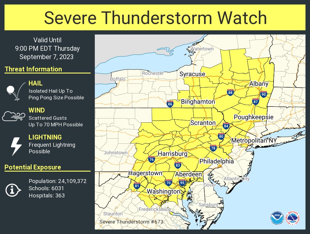
The National Weather Service’s Storm Prediction Center has issued a Severe Thunderstorm Watch for portions of Virginia, Maryland, New Jersey, Pennsylvania, and New York through 9pm tonight. While there’s always a risk of an isolated tornado from a severe thunderstorm, there are better chances that there will be damaging wind gusts and large hail from today’s storms in the northeast. Winds may gust to near-hurricane force at 70 mph while hail could grow as large as ping pong balls. The watch is in effect through 9 pm tonight. More than 24 million people live within today’s watch region.
Several things are coming together to create today’s severe weather threat. Seasonably moist air, beneath relatively steep lower and mid-tropospheric lapse rates, likely will contribute to atmospheric instability to the east of developing surface troughing to the lee of the Appalachians. According to the Storm Prediction Center, this could become supportive of developing clusters of storms with potential to produce strong wind
gusts, as convection initiates and slowly propagates off the higher terrain this afternoon. The most prominent and concentrated area of thunderstorm development still appears likely to be focused with the increasingly sheared short wave impulse and modestly strengthening southerly mid-level flow across eastern Pennsylvania and New York, and adjacent portions of the Mid Atlantic and New England, through early evening. This may include an upscale growing, and gradually organizing, thunderstorm cluster or two which may eventually pose a risk of producing a swath of strong to severe surface gusts.
Unfortunately, more severe weather is likely to return tomorrow and perhaps again on Saturday as this weather pattern is somewhat stuck, setting the stage for additional rounds of severe weather during the daytime and PM hours.
