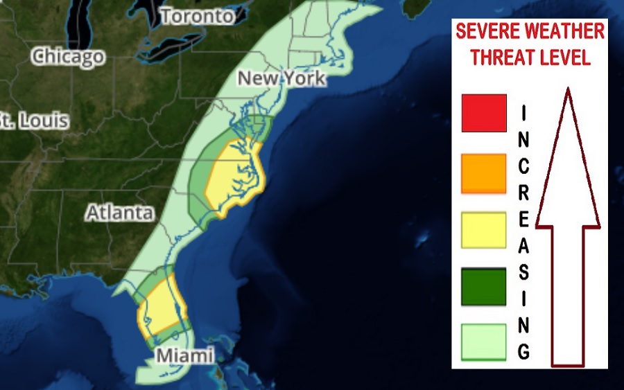
Another in a series of storm systems responsible for violent thunderstorms and destructive tornadoes to march through the country is about to head east, impacting portions of the Mid Atlantic and Florida tomorrow. In the National Weather Service Storm Prediction Center’s Convective Outlook update, strong to severe thunderstorms are possible on Thursday across eastern North Carolina and southeast Virginia, as well as across portions of the Florida Peninsula. Specifically, severe weather risks of damaging wind gusts, hail, and a couple of tornadoes will be possible in these higher risk areas.
Similar to the last severe weather system to travel across the United States, a deep upper-level trough covering much of the central and eastern continental U.S. is forecast to shift slowly eastward on Thursday, as an associated deep-layer cyclone meanders near the Great Lakes region. A cold front will sweep eastward across parts of the Mid Atlantic and Southeast through the day, and advance through most of the Florida Peninsula by Friday morning. This frontal passage will trigger the worst of the expected severe weather tomorrow.
Atmospheric conditions in the Mid Atlantic will be able to support the potential for a few supercells and organized clusters. Hail and locally damaging wind gusts will be possible with the strongest storms. The Storm Prediction Center (SPC) also warns that a couple of tornadoes will also be possible here. While the greatest threat of severe weather is over Virginia and North Carolina, a risk of severe weather will extend from northern South Carolina north to central Delaware.
In Florida, convection may be ongoing Thursday morning along a pre-frontal trough extending across the northern part of the Florida Peninsula. Additional thunderstorm development will be possible by late morning/early afternoon, as moderate to locally strong buoyancy develops within a very warm and moist environment. According to the SPC, depending on the influence of the morning pre-frontal convection, redevelopment is also possible along the primary cold front during the afternoon.
In the risk zone in Florida, atmospheric conditions will support the potential for a few organized clusters and/or
supercells. Large hail and locally strong, damaging wind gusts are expected to be the primary hazard, though low-level shear may be sufficient to support the threat for a tornado or two as well.
People in any East Coast risk zone tomorrow should make sure they’re able to get or hear any Severe Thunderstorm or Tornado Watches or Warnings that could be issued for their area tomorrow.
