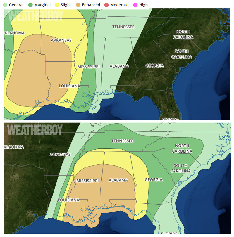
While the calendar says it’s early January, it appears a severe weather outbreak more common for the spring is about to unfold for portions of the south. According to the National Weather Service’s Storm Prediction Center (SPC), severe thunderstorms are expected by midday Friday into early Saturday morning from eastern Oklahoma and Texas into the lower Mississippi Valley. Damaging wind gusts, tornadoes and isolated large hail are all possible, especially across parts of eastern Texas into Louisiana Friday afternoon into the overnight hours.
Atmospheric ingredients will come together to provide an environment ripe for a severe weather outbreak. While it is early January, an intense boundary-parallel deep layer flow and strong atmospheric forcing are likely. In addition to creating tornadoes, these storms can also produce large hail. For now, according to the SPC, it appears the large hail potential area will likely be confined in space and time in a narrow corridor from south-central Oklahoma into north Texas. An area in eastern Texas towards the Sabine River could see strong tornadoes in addition to damaging winds and hail.
Because of the threat of overnight tornadoes, some of which could be large and especially potent, residents in risk areas in the latest SPC Convective Outlook are urged to make appropriate preparations before the storm arrives. In addition to securing loose outdoor objects, people should make sure they’re able to get, hear, and act on any severe weather alert that could be issued during the overnight hours. Often, tornado deaths occur at night when storm victims are asleep and don’t hear tornado warnings.
The threat of severe weather should diminish beyond Saturday, giving residents in the southeast time to clean-up after this unusual early January severe weather outbreak.