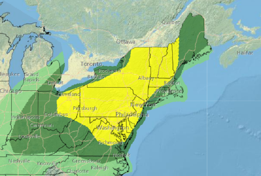
A severe weather outbreak is likely today in portions of the Mid Atlantic and Northeast as severe thunderstorms are forecast to blossom here in the afternoon heat. Thunderstorms that develop here could reach severe limits and contain damaging winds and isolated tornadoes.
According to the National Weather Service’s Storm Prediction Center (SPC), a variety of atmospheric ingredients are coming together to create today’s severe weather event. An atmosphere rich in moisture will tap into available heat to become unstable, triggering convective development today. According to the SPC, forecast soundings suggest scattered thunderstorms may develop across Upstate New York and southwest across western Pennsylvania and into eastern Ohio by lunchtime as surface temperatures warm through the 70s to near 80 degrees Fahrenheit. This activity will then develop and spread east across the Hudson Valley into portions of New England. Farther south, surface temperatures should warm into the upper 80s across the Delmarva region and this higher buoyancy may result in a greater risk of hail from eastern Pennsylvania into northern Virginia as thunderstorms develop a bit later during the mid-afternoon.
According to the SPC, damaging winds will likely be the greatest risk with multicellular updrafts that intensify during the heat of the day ahead of the short-wave trough moving through the Northeast.
The area with the greatest risk of wind damage from today’s storms is all of Pennsylvania and Maryland, New Jersey away from the shore, all but southeastern Delaware, northern Virginia, northern and northeastern West Virginia, eastern Ohio, much of New York excluding the area immediately around the Great Lakes and Long Island, all of Vermont and New Hampshire, and portions of western Maine, Massachusetts, and Connecticut.
There is also risk of isolated tornadoes today from northern Virginia north to Central Maine, and from western Ohio east to central New Jersey. The greatest risk of tornadoes, according to the SPC, will be over northeastern Upstate New York, Vermont, New Hampshire, and northwestern Massachusetts.
With these unstable conditions in the forecast, the National Weather Service could issue Severe Thunderstorm and/or Tornado Watches and Warnings as severe weather is triggered later today.