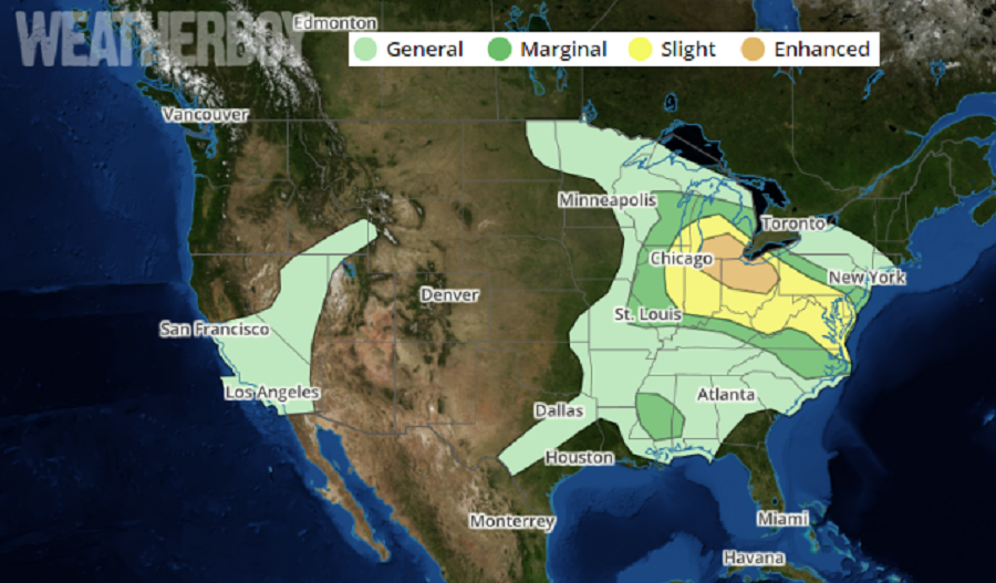
The threat of severe weather is shifting east this afternoon, with two threat areas becoming apparent. The area with the most enhanced threat exists over southern Michigan, northeastern Indiana, and the northern half of Ohio. The second area of concern is over Maryland, Delaware, and northeastern Virginia. There’s a broader threat of severe weather from eastern Wisconsin to southern New Jersey and from eastern Missouri to central North Carolina. Severe thunderstorms are possible this afternoon through tonight; the strongest storms will pose a threat for very large hail, damaging wind gusts, and a couple of tornadoes.
A very dynamic weather situation unfolding late this afternoon and tonight will result in severe weather conditions. According to the National Weather Service’s Storm Prediction Center (SPC), a combination of steep mid-level lapse rates and strong deep-layer shear will promote supercell storm structures capable of very large hail and damaging winds gusts. A tornado or two is possible with early storms, but frontal forcing should contribute to upscale organization during the early evening with increasing damaging wind risk. The SPC cautions that present indications show that storms will persist overnight and move into parts of West Virginia and Pennsylvania where nocturnal cooling will slowly diminish the severe threat.
While there’s a risk of an isolated tornado around any severe thunderstorm, the greatest chance today and tonight will be over the southern Great Lakes region. The greatest chance of damaging winds and hail will be during the early evening hours over the Mid Atlantic.
In a COVID-19 Pandemic era, it is important for people to reflect on what they’d do should a severe thunderstorm or tornado impact their area. While some structures may be safe to shelter in place from the virus, they may not be suitable shelters for high winds or tornadoes. Well before the threat arrives, people should know what they’d do and where they go should severe weather strikes.
