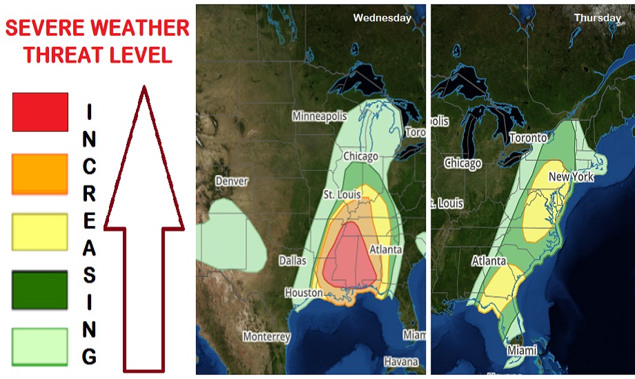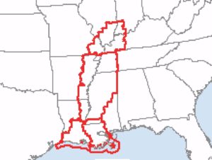
The severe weather threat level is increasing today and tomorrow in the Eastern U.S. as a potent spring storm brings a variety of weather hazards to the eastern half of the country. Today, thunderstorms are expected from Michigan to Louisiana, with especially severe conditions expected across western Tennessee, much of Mississippi, western Alabama, and eastern Louisiana. Tomorrow, the severe weather will shift east, with the greatest risk of severe weather expected over portions of New Jersey, Pennsylvania, Delaware, Maryland, Virginia, and North Carolina and across portions of the Florida panhandle, southeastern Georgia, and southern South Carolina. Damaging winds, destructive hail, and lethal tornadoes are all possible from this latest storm system to impact the U.S..

A regional outbreak of severe thunderstorms is expected from the
Lower Mississippi Valley into parts of the Ohio and Tennessee
Valleys today, and over portions of the central Gulf Coast states
later today into tonight. This trouble area shifts to the East Coast tomorrow. According to the National Weather Service’s Storm Prediction Center (SPC), the greatest concerns are tornadoes, some of which will be strong EF2 or stronger rated and widespread damaging wind gusts, with some gusts to hurricane force expected.
Today’s atmospheric set-up will foster the rapid intensification of thunderstorms over Arkansas and Louisiana that spread rapidly eastward into portions of Illinois, Kentucky, Tennessee, and Mississippi later today. Low-level wind fields are also expected to intensify rapidly ahead of the line of storms, resulting in very favorable shear profiles for supercells and/or bow/lewp structures along the squall line. Widespread damaging winds are possible across these areas, with the risk of several tornadoes as well.
As the storms move eastward into central Kentucky and the middle of Tennessee later today, they will move into an area with an unfavorable thermodynamic environment. As such, there should be a slow weakening of the damaging wind threat along the line of storms there. However, a risk of damaging winds will persist as far east as this area tonight.
The primary squall line will track eastward across Mississippi and Louisiana and into Alabama by early this evening, bringing a risk of damaging winds to those areas. Convective intensity may decrease during the evening across northern Alabama, but greater low-level moisture farther south should allow the storms to remain potentially severe through much of the night. Meanwhile, low-level shear profiles will remain quite strong and capable of producing tornadoes.

Tonight, it appears the threat for damaging winds and tornadoes will continue through the night into early Thursday morning across much of Alabama and the western Florida panhandle as the line shifts east. According to the SPC, low-level shear is expected to remain quite strong across this region, and rich low-level moisture will be present as well. The SPC warns, “If the line transitions into a broken/more semi-discrete mode as some high-resolution guidance suggests, then a threat for strong tornadoes may be realized, mainly across parts of southern and central Alabama and the Florida Panhandle overnight.”
Unfortunately, the threat of severe weather won’t end there. The disturbance responsible for this stormy weather will head east, with a fresh area of severe weather expected to develop in portions of the Mid Atlantic.
Large-scale upper troughing will encompass much of the central and eastern continental U.S. on Thursday, allowing for multiple shortwave troughs to rotate through during the day. As they rotate through, there will be multiple rounds of severe thunderstorm potential extending from parts of the Southeast to the Mid-Atlantic.
The broken line of storms should be ongoing Thursday morning into Thursday afternoon over parts of the Florida panhandle into southern and central Georgia. Both damaging winds and a couple of tornadoes appear possible here. The SPC says there’s some potential that storms could re-strengthen Thursday afternoon into more of northern Florida and coastal Georgia and South Carolina as daytime heating occurs. A lingering, isolated severe weather threat could persist into the evening hours ahead of a cold front’s passage.

More action will head more north. The northern portion of an ongoing squall line will extend across the western Carolinas Thursday morning. Poor lapse rates and preceding showers and cloudiness will likely temper instability with the eastward extent across South Carolina, North Carolina, and Virginia. Daytime heating should allow for some strengthening of the line from central North Carolina into southeastern Virginia and the Delmarva Peninsula by Thursday afternoon. This will set the stage for severe storms with damaging wind gusts and brief, isolated tornadoes embedded within the line.
North of here across the Mid Atlantic, the severe threat should increase along and ahead of the cold front, which is expected to move through during the late afternoon and evening hours. According to the SPC, modest instability should develop ahead of the front amid filtered daytime heating and cooling mid-level temperatures; low to mid-level flow across this region will remain strong. As a result of the modest buoyancy and robust vertical shear, isolated strong to severe thunderstorms will blossom. “Damaging winds are the primary threat, but low-level vertical shear is strong enough to support a tornado or two. Some marginally severe hail may also
occur,” the Storm Prediction Center warns.
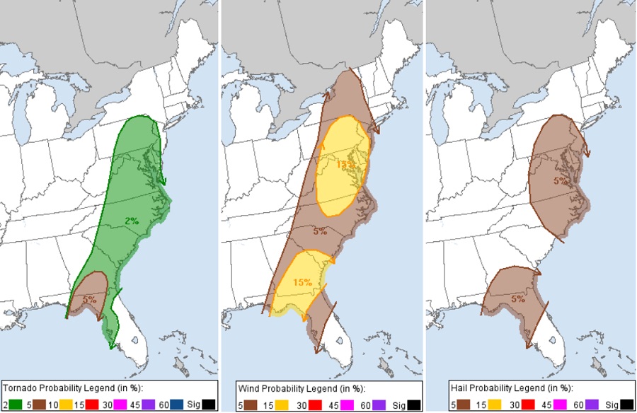
A risk of tornadoes will exist from central Pennsylvania and New Jersey south through Maryland, Delaware, Virginia, North and South Carolina, southeastern Georgia, and northern Florida. At this time, it appears the greatest risk of tornadic cells will be over the central panhandle of Florida and southern Georgia.
The threat of destructive winds, some gusting to or over hurricane force, will exist tomorrow from Upstate New York south into central Florida. The greatest risk of damaging winds will be over New Jersey, eastern and central Pennsylvania, much of Maryland, all of Delaware, and portions of Virginia, North and South Carolina, southern Georgia, and northern Florida.
An elevated risk of large, damaging hail also exists in Thursday’s storms. The greatest threat of damaging hail is over eastern Pennsylvania, much of Maryland and New Jersey, all of Delaware, eastern Virginia and North Carolina, northern and central Florida, and southern Georgia.
Fortunately the severe storm threat will dissipate later Thursday evening as the impacts from daytime heating leave and the atmospheric disturbance slides off the U.S. east coast.