A storm system responsible for numerous tornadoes, and unfortunately fatalities too, continues to push east today, prompting another series of tornado watches and warnings. According to the National Weather Service’s Storm Prediction Center (SPC), this area of severe weather will shift east tomorrow too, bringing a severe weather threat back to the Mid Atlantic –including portions of New Jersey and Delaware that saw a record tornado outbreak over the weekend.
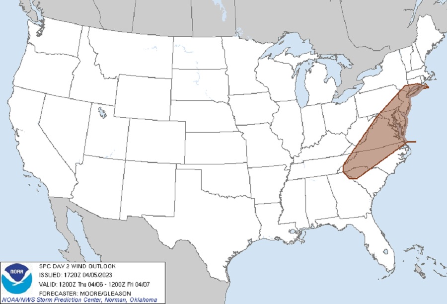
According to the SPC, isolated strong to severe thunderstorms are possible across parts of the southern Appalachians into the Mid-Atlantic, as well as across southern/coastal Texas, Thursday afternoon and evening. Within this area, there is an elevated threat of damaging winds from northern South Carolina across much of western and central North Carolina, much of Virginia and Maryland, all of Delaware and New Jersey, and portions of Pennsylvania, New York, and Connecticut, including the Washington DC, Baltimore, Philadelphia, and New York City metro areas.
The National Weather Service defines dangerous winds with different criteria. To be considered severe, associated wind gusts must be 58 mph or greater. “Strong Wind Gusts” are thunderstorm wind gusts between 39 mph and 57 mph; “Damaging Wind Gusts” are severe thunderstorm wind gusts between 58 mph and 74 mph. “Very Damaging Wind Gusts” are severe thunderstorm wind gusts between 75 mph and 91 mph causing moderate damage. “Violent Wind Gusts” are severe thunderstorm wind gusts greater than 92 mph causing major damage.

According to the SPC, the upper wave currently over the north-central U.S. is expected to continue lifting to the northeast into southeastern Canada over the next 48 hours. By Thursday afternoon, a nearly straight mid-level jet streak will likely be in place from the Great Lakes region into southern Quebec. At the surface, a trailing cold front, currently pushing eastward across the Midwest and southern U.S., is expected to slow as it migrates into the Mid-Atlantic, Southeast, and Texas Gulf Coast regions. Thunderstorms will likely be ongoing along portions of this boundary during the early morning hours and their longevity through the morning/early afternoon hours is uncertain due to an increasing displacement from stronger synoptic ascent to the north. Redevelopment along this boundary by late afternoon/early evening appears likely across the southeast states to the Mid-Atlantic region and may feature a few strong to severe thunderstorms.
Thunderstorm development along the cold front appears probable along the southern Appalachians into the Mid-Atlantic region Thursday afternoon. The moist air mass currently in place across the Carolinas will shift north through the day, supporting the formation of some severe weather. While the overall parameter space will support supercells, storm motions and deep-layer shear vectors largely oriented along the initiating cold front suggest that initially discrete cells may grow upscale into clusters and/or lines. It remains somewhat uncertain how quickly this transition will take place, and a more robust hail/wind threat may emerge if discrete modes can be maintained through the afternoon.
Unlike Saturday’s event which had atmospheric ingredients ripe for tornadic development, damaging wind gusts will be the primary concern with these storms followed by a large hail threat. While isolated tornadoes could be possible, it’s unlikely to be like Saturday’s severe weather event.
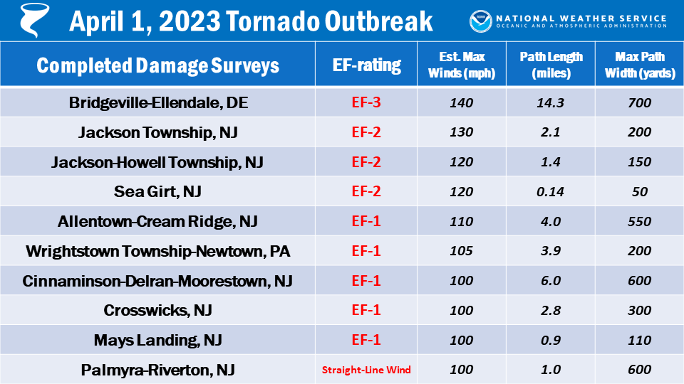
On Saturday, New Jersey broke its record for the most number of tornadoes in a single day. A total of 8 tornadoes touched down in Jackson Township, Howell, Sea Girt, Allentown, Cream Ridge, Cinnaminson, Delran, Moorestown, Crosswicks, and Mays Landing. A tornado also touched down in Wrightstown Township and Newtown in Pennsylvania. A lethal EF-3 tornado struck the Bridgeville-Ellendale, Delaware area too, killing one person when the tornado forced his house to collapse in on him. This death is the first death from a tornado in Delaware since 1983.