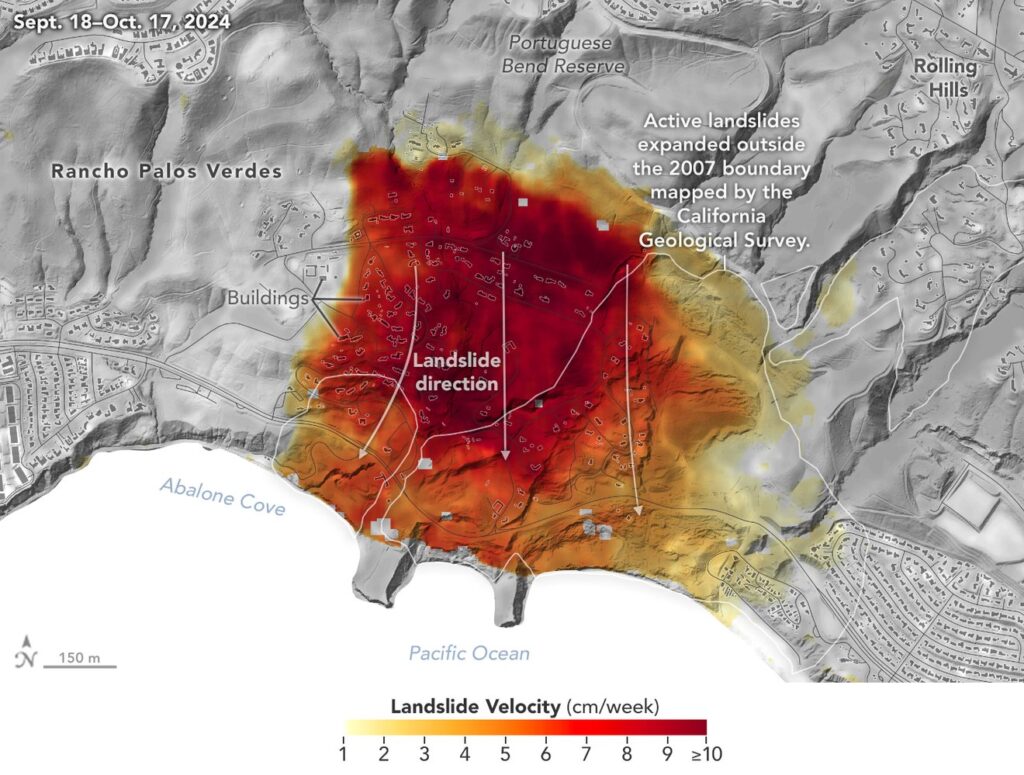
Shocking imagery released by NASA shows portions of Los Angeles County are sliding into the Pacific Ocean at an incredible 4″/week rate. Analysis of data from NASA radar aboard aircraft shows that the decades-old active landslide area on the Palos Verdes Peninsula has expanded in size and has increased in forward motion to the sea. Researchers at NASA’s Jet Propulsion Laboratory (JPL) in Southern California used data from an airborne radar to measure the movement of the slow-moving landslides on the Palos Verdes Peninsula in Los Angeles County. The analysis determined that, during a four-week period in the fall of 2024, land in the residential area slid toward the ocean by as much as 4 inches or 10 centimeters per week.
Portions of the peninsula, which juts into the Pacific Ocean just south of the city of Los Angeles, are part of an ancient complex of landslides and has been moving for at least the past six decades, affecting hundreds of buildings in local communities. The motion accelerated, and the active area expanded following record-breaking rainfall in Southern California in 2023 and heavy precipitation in early 2024.
The area has seen roads and structures crumble and collapse in the region in recent months, forcing utility shut-offs, road closures, and evacuations as the local terrain collapses towards the sea.
NASA said to create this visualization, the Advanced Rapid Imaging and Analysis (ARIA) team used data from 4 flights of their Uninhabited Aerial Vehicle Synthetic Aperture Radar (UAVSAR) that took place between September 18, 2024 and October 17, 2024.
The UAVSAR instrument was mounted to a Gulfstream III jet flown out of NASA’s Armstrong Flight Research Center in Edwards, California, and the four flights were planned to estimate the speed and direction of the landslides in three dimensions.
In the fall, some Rancho Palos Verdes homeowners in the Greater Portuguese Bend landslide area who had been plagued by shifting land underneath and around their homes were offered a $42 million voluntary buyout Monday by the Federal Emergency Management Agency (FEMA) and the California Governor’s Office of Emergency Services.
Not everyone has taken the buy-out and many people remain living in the area. There are also dozens of people attempting to sell their homes; according to Zillow, home prices range from $1.7 million to more than $10 million in this area.
Rancho Palos Verdes sits on top of a volcanic ash bed, laid down about 10 to 15 million years ago, that slopes down to the Pacific shoreline of southern California. As it rains, water seeps into the ground, percolating into the layers below where it can reduce the suction and friction holding together grains of soil or rock, causing the ground to weaken and shift. With gravity helping to “normalize” the ground, the slopes are being pulled down towards the ocean, taking the community built atop it with it.
Rainy periods, such as the one forecast to impact the region tomorrow, make matters worse, with the rain serving as a lubricant of source to accelerate the movement towards the sea.
