After a significant warm-up the second half of the week in the eastern United States, a strong cold front is forecast to move through Sunday night into Monday, possibly setting off significant, severe weather as it does so.
The ingredients for the severe weather outbreak will assemble over the weekend. A robust upper-level trough and closed low across the Plains on Friday if projected to move east with a downstream building ridge ahead of it. A closed low in eastern Canada is forecast to shift east, allowing strong surface high pressure to build east-southeast from the Hudson Bay over the weekend. Such a set-up will surge very warm air up the US east coast. Some precipitation along and north of a main frontal zone initially over New England will allow for enhanced cooling across the northeast. This combined with surface high pressure pressing east-southeastward should drive the boundary southward as a backdoor front. The warmth is forecast to peak on Saturday ahead of the potential backdoor front arriving with temperatures rising into the low 80’s across the northern Mid Atlantic, away from the ocean. Once the backdoor front arrives, though, the low-level flow should start to turn more onshore allowing for cooling to take place through Sunday night in the northeast. This all occurs as low pressure gradually approaches from the west Sunday, sweeping to the coast late Sunday night and early Monday morning.
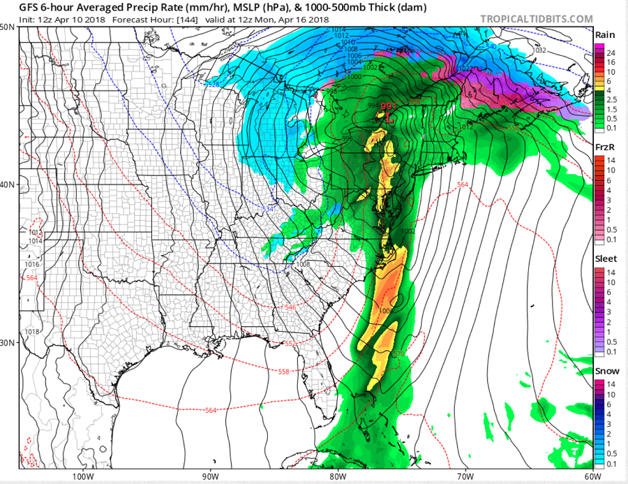
Ample moisture and large scale ascent joining the strong trough aloft, the low pressure system at the surface, and the cold front will trigger widespread showers later Sunday into early Monday across the entire US East Coast. With a plume of instability flowing ahead of the front, thunderstorms will form. Some thunderstorms could reach severe limits, especially in the most unstable portions of the atmosphere. It is still too early to know exactly where along the East Coast will see the most unstable air, but everyone from Florida north to New York should monitor severe weather threats as the weekend wraps up.
Severe thunderstorms contain, winds of 58mph or greater, hail of 1″ or greater diameter, and/or a tornado. Thunderstorms do not need to be severe to contain frequent lightning. With the second lightning fatality of the year this weekend, meteorologists are urging caution ahead of this next round of thunderstorm activity. People should remember: if thunder is close enough to be heard, lightning is close enough to kill; when thunder roars, head indoors!
