As the Thanksgiving Holiday Weekend wraps up, Old Man Winter may be making a surprise visit to portions of the northeast with an early season snowstorm. As low pressure winds up along the northeast coast later Sunday into Monday, snow, heavy at times, could fall over portions of New Jersey, New York, Connecticut, Rhode Island, and Massachusetts. Accumulating snow is also possible in places like Philadelphia, Pennsylvania and Newark, Delaware.
Even if accumulations aren’t very deep, a storm at the close of the holiday weekend could create travel nightmares as people return from the holiday and head home. Newark’s Liberty Airport, which serves as a hub for United Airlines, Philadelphia’s PHL Airport, which serves as a hub for American Airlines, and Boston’s Logan Airport, which serves as a hub for JetBlue could all see ramifications throughout their network as these hubs are impacted by frozen precipitation. Delays and flight cancellations would be possible there or elsewhere throughout the nation because of impacts on aircraft at key hubs.
Roads could also become slick and dangerous. For some portions of the northeast, this could be the first plowable snow event. Plowable snows compounded by first-time winter drivers and holiday traffic jams could prove to be problematic even in the I-95 corridor between Philadelphia and Boston.
An upper level ridge providing Black Friday’s good weather in the eastern United States will start to erode as a low pressure system starts to undergo strong cyclogenesis over the plains into the Ohio Valley region. This area of low pressure was the “bomb cyclone” that hit the western United States earlier this week, producing record strong winds on the west coast while dumping heavy snow in and around the Denver metro area.
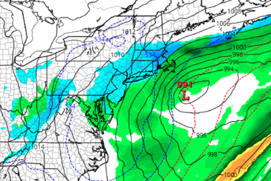
As the low approaches on Sunday, a mixed bag of weather will unfold. Warm advection ahead of the primary low Sunday morning will create snow quickly turning to wintry mix becoming mostly rain south of I-76 in Pennsylvania. 1 to 3″ of snow could fall on the higher terrain of Carbon and Monroe Counties on Sunday. By Monday afternoon the upper level trough will be centered over the region and a coastal low will become the dominant feature. As cold air wraps around this new dominant feature, rain is expected to change to snow over much of eastern Pennsylvania, northern Delaware, New Jersey, New York, Connecticut, Rhode Island, and Massachusetts. Depending on how strong the storm gets and how much cold air it is able to tap into, some snow could be heavy at times, especially early Monday morning.
It is still too early to see just exactly how this storm will unfold and who will get how much snow. However, odds for the heaviest snow right now are over northern New Jersey, southern Upstate New York, northern Rhode Island, and southern and western Massachusetts away from the ocean. People from Philadelphia to Boston should watch evolving forecasts for the threat of accumulating snow this weekend. As the threat begins to materialize, the National Weather Service will issue Winter Weather Advisories, Winter Storm Watches, and Winter Storm Warnings as it becomes necessary.
