• Skip to primary navigation
  • Skip to main content
  • Skip to primary sidebar

Weatherboy

Weatherboy Weather News, Maps, RADAR, Satellite, and Forecasts.

  • Local
  • Earth Science News
  • RADAR
  • Current Warnings
  • Satellite
  • Current Maps
  • Forecast Maps
  • Video

Strong Tennessee Earthquake Reported by 35,000+ People

by Weatherboy Team Meteorologist - May 10, 2025

The epicenter of today's earthquake is located at the orange dot inside the colored concentric circles on this map.  Image: USGS
The epicenter of today’s earthquake is located at the orange dot inside the colored concentric circles on this map. Image: USGS

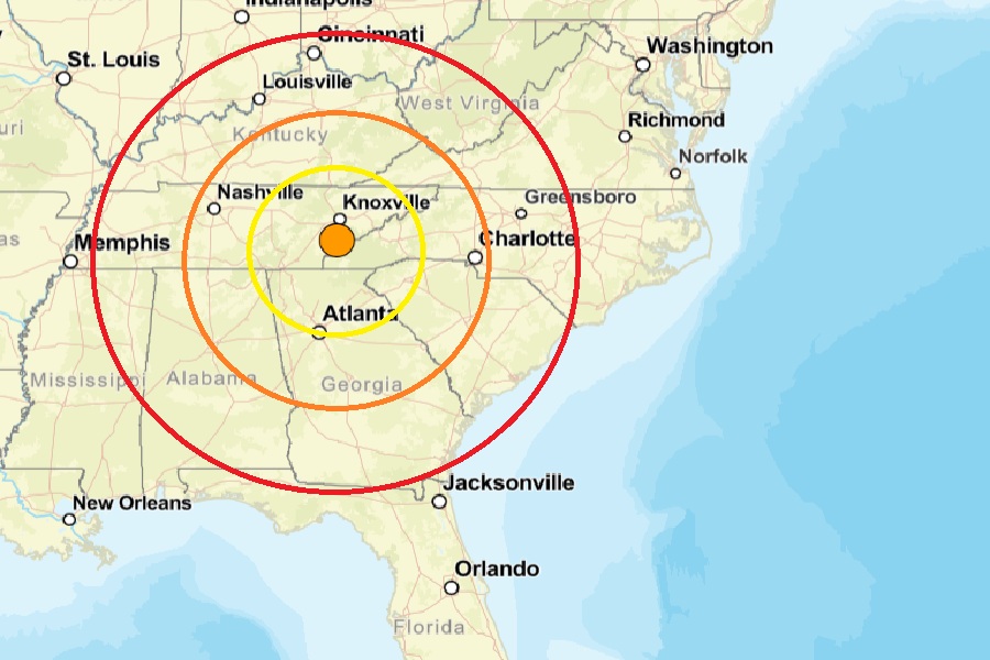
A stronger than usual earthquake struck eastern Tennessee this morning; according to USGS, more than 35,000 people used the “Did you feel it?” website reporting tool to report they felt shaking from the quake.  At 8:04 am today from a depth of 24.9 km, the magnitude 4.1 earthquake struck near Greenback which is located south of  Knoxville and between Chattanooga, Tennessee and Asheville, North Carolina. This area is also roughly 150 miles north of Atlanta, Georgia and many people across the Atlanta metro region reported feeling the earthquake.

According to USGS, earthquakes with a magnitude of 2.0 or less are rarely felt or heard by people, but once they exceed 2.0 , more and more people can feel them. While damage is possible with magnitude 3.0 events or greater, significant damage and casualties usually don’t occur until the magnitude of a seismic event rises to a 5.5 or greater rated event.

This isn’t the first earthquake to shake Atlanta from Tennessee. In December 2018, two earthquakes struck Tennessee . One was a 4.4 magnitude event that was centered in Decatur, Tennessee, which is south of Knoxville. It shook homes as far away as Atlanta.

Reports of damage and injuries have not yet been confirmed from today’s earthquake.

Earthquake hazards are possible in broad areas of the United States. Earthquake hazard map showing peak ground accelerations having a 2 percent probability of being exceeded in 50 years, for a firm rock site. The map illustrates such hazards and is based on the most recent USGS models for the conterminous U.S. (2018), Hawaii (1998), and Alaska (2007). Image: USGS


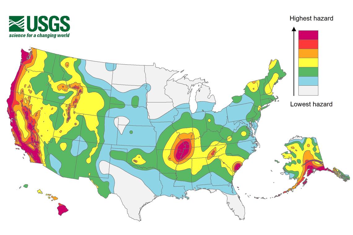
Earthquakes like the one that this morning in the eastern part of Tennessee are unlikely associated with the New Madrid Seismic Zone, an area of ongoing seismic activity located near the Mississippi River. However, while USGS says western Tennessee has a higher frequency of damaging earthquake shaking, the risk isn’t that low in eastern Tennessee.  In the area of this most recent quake, USGS says its likely this area would see 50-100 damaging earthquakes over 10,000 years. While this number is low, it is much higher than it is elsewhere in the eastern half of the United States, where it’s likely to have 10 or less earthquakes over the same period.


Primary Sidebar

Sponsored Ad

Search

Latest News

  • Igloo Cooler Recalled Due to Amputation / Crushing Threat
  • Longtime TV Meteorologist Fired
  • Spacecraft Launched by Soviet Union in 1972 Crashed Back on Earth Today
  • Strong Tennessee Earthquake Reported by 35,000+ People
  • Updated Crash Forecast Puts Eastern U.S. on Alert from Soviet Union Spacecraft
  • Soviet Union Spacecraft Crash Zones Updated; NJ/NY/PA/MI at Increased Risk
  • Over 2,000 People Report Shaking from Virginia Earthquake
  • Morning Earthquake Strikes Heart of New Madrid Seismic Zone in Missouri Today
About | Careers | Contact | Contests
Terms | Privacy | Ad Choices
Weatherboy is a (R) Registered Trademark of isarithm LLC, All Rights Reserved.
All content herein is Copyright by Isarithm LLC 1997-2022