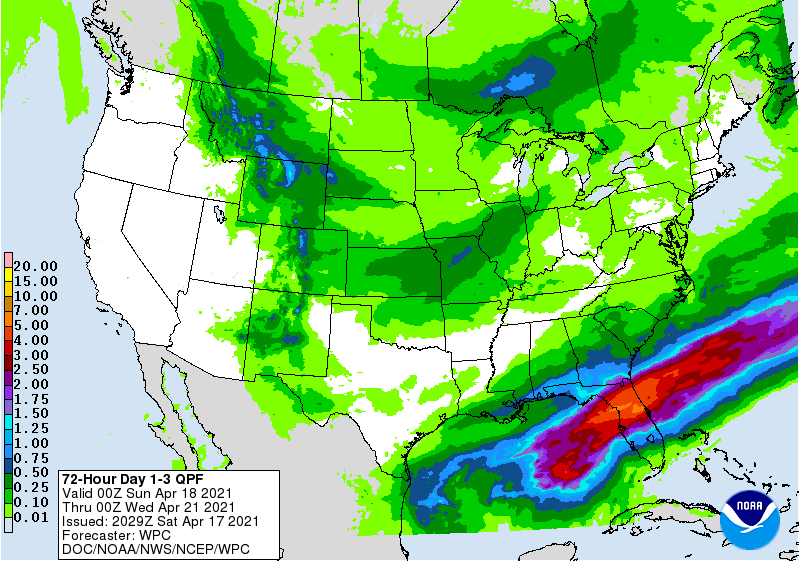
Soaking rain and flash flooding threats will visit Florida over the next three days as a frontal system ever so slowly creeps south through the Sunshine State.
For now, a warm front is located near the Florida / Georgia state line with a weak meso high just east of the area over the Atlantic waters with showers and embedded thunderstorms beginning to fill in over the Florida Panhandle, southwest Georgia, and farther west along the Gulf coast. According to the National Weather Service, a strong mid/upper level west-southwest flow is streaming dynamic energy towards the region, reinvigorating convection as unstable shortwave energy travels into Florida. This will help bring showers and isolated storms into the region through tomorrow.
Because 1-2″ of rain already fell yesterday, with some areas receiving up to 2-4″ locally near Ocala, a flood threat exists. An additional 1-2 inches of rain are expected through early Sunday morning with locally heavier amounts as the saturated airmass with atmospheric conditions favoring more efficient rainfall rates. Areas with poor runoff near urban centers may also see a risk for isolated flash flooding potential as well should any storms train over the same areas.
This boundary area will ever so slowly drift to the south, shifting the axis of heavy rain from near the Florida/Georgia border closer to Orlando and the central Florida resorts area. By Wednesday morning, it is possible some areas here will see rainfall totals of 5-7″ with localized heavier amounts.
The National Weather Service cautions all to avoid driving through flood waters. “Turn around, don’t drown; never drive through flood waters” they said in a flood statement.
