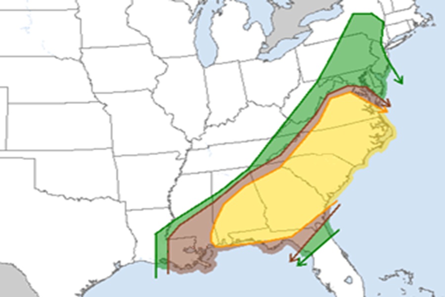
March is going to go out with the roar of a lion with tornadic thunderstorms and flooding rains possible across a large portion of the U.S. East Coast on Monday from New Jersey to Florida. According to the National Weather Service’s Storm Prediction Center, there is an enhanced risk of severe thunderstorms for parts of the central Gulf Coast, the southeastern U.S., and up into the Carolinas and Virginia too.
Strong to severe thunderstorms, with a threat for scattered to widespread damaging winds and several tornadoes are forecast Monday from portions of the Northeast southwestward to the central Gulf Coast region. According to the Storm Prediction Center (SPC), the primary synoptic features on Monday will be influenced by extensive antecedent and ongoing convection, but in general, one significant mid and upper-level shortwave trough will move from the lower Great Lakes toward the Canadian Maritimes, while a lower-amplitude midlevel shortwave trough will move from the Mid-South/Southeast toward the Carolinas/Mid Atlantic. A deep surface low will move across Quebec through the day, as a trailing cold front advances southeastward from the Northeast/New England into parts of the Southeast.
An organized storm cluster is forecast to get going on Monday morning across parts of Louisiana, Mississippi, and Alabama, potentially aided by the trailing shortwave trough moving out of the southern Plains. Favorable low-level moisture, moderate downstream buoyancy, and strong upper-level winds will help to maintain the potential for an organized cluster to move eastward into parts of Georgia and South Carolina through the day, accompanied by a threat for scattered to widespread damaging winds. The SPC says conditions will be sufficient to support some tornado threat as well. In addition to a tornado threat, any sustained supercells would also pose a threat of isolated hail.
The anticipated storm cluster will tend to outpace the primary cold front, with some potential for at least isolated development in the wake of early-day convection.
In addition to a severe weather threat and elevated risk of tornadoes in parts of New Jersey and Pennsylvania and points south, we are also watching the possibility of heavy excessive rain around and in the New York City metro area too: https://t.co/zGUkptCrwc
— the Weatherboy (@theWeatherboy) March 31, 2025
Farther north into parts of North Carolina and Virginia, a relatively strong heating of a moist environment will result in moderate buoyancy by early afternoon, though midlevel lapse rates will likely remain weak. Scattered thunderstorms are expected to develop and spread eastward, with potential for a few organized cells or clusters capable of damaging wind. There will be some potential for an increase in low-level flow, shear, and moisture later in the afternoon, which could increase the tornado threat, depending on the timing of storm initiation and maturation.
While instability will generally weaken with northward extent, scattered thunderstorm development is expected along/ahead of the front as far north as parts of New York and southern New England. Low/midlevel flow will remain somewhat enhanced along the southern periphery of the cyclone across Quebec, and some potential for damaging gusts and perhaps a tornado may accompany the strongest storms through the day and into the early evening, before the front moves offshore.
