
According to the National Weather Service’s Storm Prediction Center (SPC), there is an elevated risk of tornadoes in portions of Pennsylvania, New York, Ohio, West Virginia, Mississippi, and Alabama today.
The reason for today’s severe weather threat is an upper level low which is centered this morning over Minnesota and Wisconsin, with broad cyclonic flow across much of the eastern US. According to the SPC, several clusters of thunderstorms are ongoing this morning across from east Texas into Georgia, with a risk of occasional gusty winds.
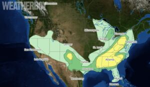
“A few hours of sunshine may be sufficient for intensification of one or more of these clusters, with damaging wind being the main concern,” says the SPC in their latest Convective Outlook.
A similar regime is present this morning along a cold front from northwest Ohio into Illinois, Scattered strong thunderstorms may develop anywhere along the front from central Pennsylvania into southeast Missouri. The SPC says that atmospheric forcing is weak so most storms will remain somewhat disorganized. However, the strongest storms will pose a risk of locally damaging wind gusts along with isolated tornadoes.
Yesterday was an active day with significant severe weather too. According to the SPC, there were 5 tornadoes, 154 reports of damaging wind, and 84 reports of damaging hail.
