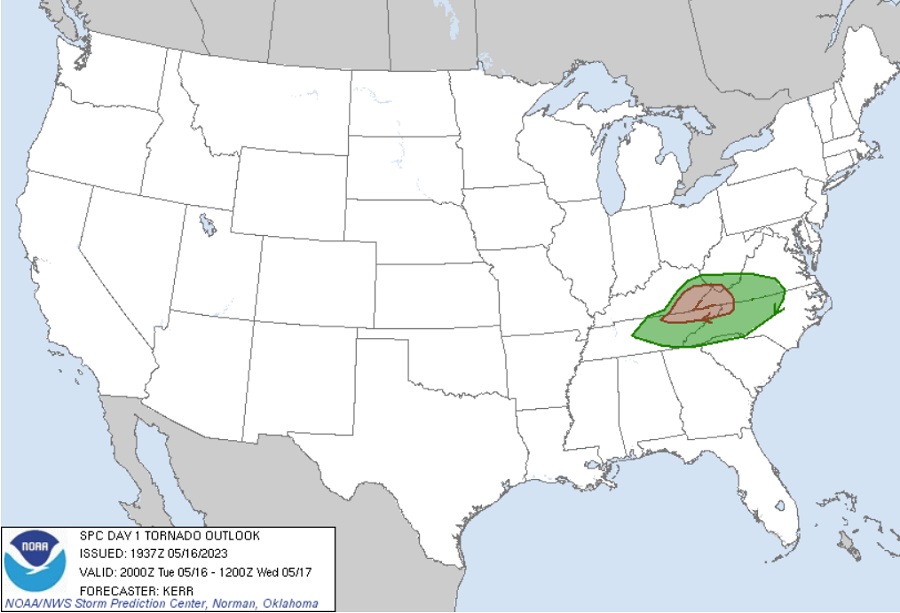
A severe weather outbreak is moving through the eastern United States today, with an elevated threat of severe thunderstorms and isolated tornadoes across portions of Virginia, North Carolina, Tennessee, Kentucky, and West Virginia. The threat of tornadoes will persist into the evening hours tonight in the region, bringing a threat of tornadoes in the dark of night to many.
According to the National Weather Service’s Storm Prediction Center, an organizing cluster of thunderstorms is forecast to gradually intensify, with increasing risk of producing damaging wind gusts while spreading across the Cumberland Plateau and adjacent Appalachians, through the Virginia and North Carolina Piedmont by late evening. Due to the threat, the SPC has issued Severe Thunderstorm Watches for the threats of severe thunderstorms with damaging winds, large hail, and isolated tornadoes across portions of southern West Virginia, southern and western Virginia, much of the western half of North Carolina, far eastern Kentucky, and much of northeastern Tennessee.
A shortwave mid/upper trough moving across the Ohio Valley and Central Appalachians today, and into the Mid-Atlantic tonight is responsible for the severe weather. A weak surface lee trough is evident across the Virginia/North Carolina Piedmont and the surface low should track roughly east and northeast through the balance of the day with a trailing cold front spreading across the region this evening. High dewpoints and strong heating from earlier today have destabilized the atmosphere, creating conditions ripe for severe thunderstorm and even tornadic development.
According to the SPC, initial semi-discrete cells are expected, posing a risk for hail and damaging wind gusts. Steep low-level lapse rates will also support strong outflow and convection will likely transition toward bows as storms shift east across the spine of the Appalachians. A swath of strong gusts may persist east of the Appalachians in a moist and unstable downstream environment. The SPC also says that there could be more than one round of strong or severe thunderstorm across the Virginia and North Carolina Piedmont area. “Initial activity associated with the lee trough may pose a hail/wind risk, while any emerging bow/MCS (mesocyclone system) by late afternoon/early evening may also result in a damaging wind risk,” the SPC warned in their latest Convective Outlook issued today.
The severe weather threat will diminish here by or near midnight.
Tomorrow, thunderstorms are expected to re-fire again across southern portions of Mississippi, Alabama, and Georgia. However, the threat of severe storms and tornadoes tomorrow is not nearly as high as it is today.
