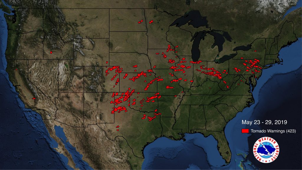
forecast offices issued a combined 423 Tornado Warnings for portions of 27 states. Image: NWS
Meteorologists at the Mount Holly, New Jersey office of the National Weather Service have completed their surveys of storm damage in Pennsylvania and New Jersey, bringing the number of confirmed tornadoes to three this week. Tornadoes touched down in Sussex County, New Jersey and Lancaster, Berks and Bucks Counties in Pennsylvania.
The scale that rates the intensity of tornadoes is known as the Enhanced Fujita Scale; it classifies tornadoes based on their wind speeds. EF-0 tornadoes have wind speeds 65 to 85 mph; 1 has winds 86 to 110mph; 2 has winds 111-135mph; 3 has winds 136-165mph; 4 has winds 166-200mph; 5 has winds in excess of 200mph.
The first tornado of the bunch occured in Morgantown, Pennsylvania on May 28 at 5:52pm. The tornado, determined to be an EF-2 on the Enhanced Fujita Scale, started in Caernarvon Township in Lancaster and lifted up 2.6 miles away in Berks County. This tornado had estimated maximum wind speeds of 120mph and had a path width of about 400 yards. There were no deaths or injuries with this tornado. According to the damage assessment from the National Weather Service, damage began at a turkey farm in the area, where several trees were snapped and the roof of a barn was loften and blown to a residence. In the process, 40 turkeys were killed. The tornado then affected a residence on Swamp Road, with substantial damage to two outbuildings, one of which was completely destroyed. The roof of one of the buildings ended up underneath a van that was lofted as well. A tractor trailer on the property was overturned and dragged nearly 40 feet from its initial position. The tornado then moved into Morgantown, where sporadic damage occurred to several businesses there on Main Street. There, the tornado downed numerous large and healthy trees and shifted to a more southeast direction. Moving into the Valley Ponds subdivision, the tornado damaged several homes, with roof and window damage visible. At least a dozen vehicles there were shifted and severely damaged, including one which was overturned several times, ending up 30-40 feet beyond its original position. The tornado then moved into a nearby industrial park where numerous trees snapped, more cars were shifted, and several buildings saw roof damage. Finally, the tornado damaged more homes and lifted near the end of Quarry View Drive.

The next tornado touched down in Stanhope in Sussex County, New Jersey at 8:30pm on Tuesday. This tornado, rated an EF1, had estimated maximum sustained winds of 100mph; it had a path width of 350 yards and traveled roughly 1.2 miles, although it lifted from time to time on its journey through northern New Jersey. The tornado initially touched down near the Lenape Valley Regional High School. There, several trees were snapped or uprooted. According to the National Weather Service, a clear tornadic damage path was seen with three nearby trees snapped or uprooted in a cyclonic fashion. A small, but anchored outbuilding serving as a dugout for the nearby ballfield, was lifted and flipped over. A banquet was underway inside the school at the time of the tornado, temporarily trapping those students, teachers, and guests inside. Two people from the school were injured but rejected medical help at the scene. The tornado damaged a residence across the street from the school. Further southeast, additional tornado damage was observed, with trees, homes, and cars showing signs of storm-related impacts.
The third tornado touched down on Wednesday at 3:14pm. The weakest of the bunch, the tornado was rated an EF0 with estimated maximum winds of 80mph. The tornado was on the ground for 7 minutes, traveling 2.3 miles; it had a path width of only 50 yards. This tornado reached the ground near the intersection of Kings Highway and East Mill Hill Road in the southern portion of Lower Milford Township in Lehigh County. The tornado then lifted and descended several times as it traveled east and southeast, crossing over the Bucks County Line into northern portions of Mildford Township before lifting the final time northwest of Spinnerstown. The primary damage from this tornado was tree related, with numerous trees snapped or downed. At least one home in the path of this storm sustained roof damage from a fallen tree. No injuries or deaths were reported with this storm.
The tornadoes formed in a multi-day severe weather outbreak that created numerous Severe Thunderstorm Warnings and Tornado Warnings for portions of the Mid Atlantic. Overall, the last week of May was a busy-one, severe weather wise, with more than 420 Tornado Warnings and more than 1,630 Severe Thunderstorm Warnings issued across the country.