A potent spring storm system will bring the threat of severe storms to portions of the northern Mid Atlantic region while heavy snow is likely over portions of northern New England from the same system.
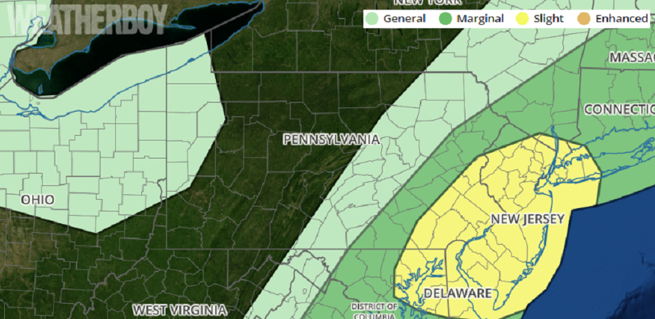
In the latest Convective Outlook from the National Weather Service’s Storm Prediction Center, meteorologists there paint the bullseye for Thursday’s severe weather event on New Jersey and nearby areas; the Philadelphia and New York City area are included too. This area has the best odds for severe thunderstorms in the eastern United States; New Jersey also has the highest odds for isolated tornadoes.
While many will see thunderstorms today, not everyone will see severe ones. The same is true for tornadoes: they will be very isolated and likely few and far between. However, the National Weather Service is urging people to remain weather ready and storm aware as these storms fire-up later today.
As a rapidly deepening surface low slowly moves into the
Northeast today, a warm front will lift north through the Mid Atlantic this morning before a cold front sweeps through this afternoon. It is the passage of this cold front that’ll trigger severe weather from Connecticut south today, with the greatest threat of severe weather expected over New Jersey.
Beyond isolated tornadoes, thunderstorms that fire up could contain damaging wind gusts, hail, frequent lightning, and heavy rain. Some heavy rain may create some flash flood conditions in isolated areas.
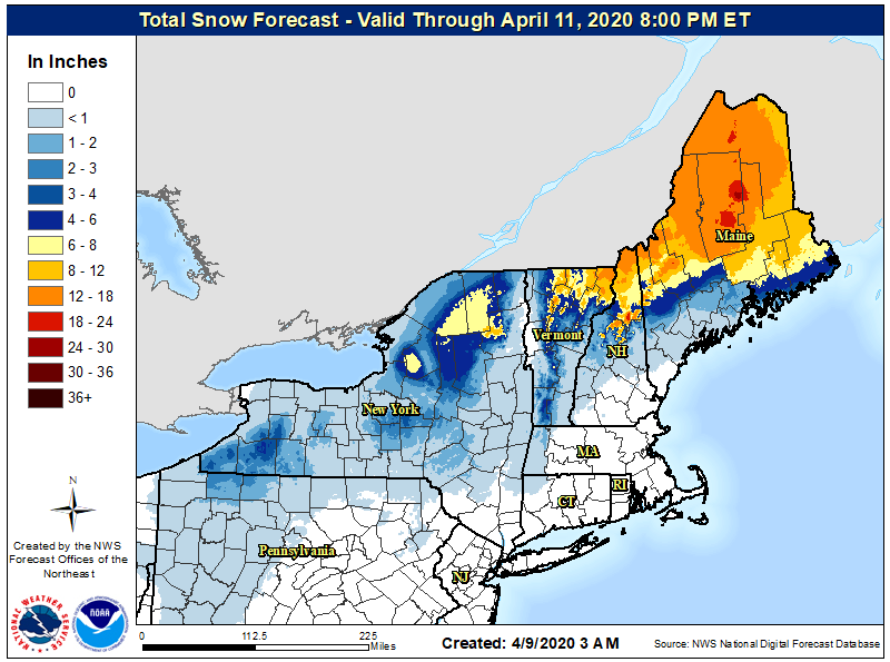
While the northern Mid Atlantic is facing the threat of severe storms, very heavy snow is expected over portions of New England. The low responsible for the rough weather in New Jersey will lift slowly toward the Canadian Maritimes on Friday and Saturday, dropping heavy wet snow as it does so across northern New England and especially Maine. The northern half of Maine should see more than a half foot of snow, with some locations forecast to get 18-24″ of snow this weekend. Because of this, the National Weather Service has issued Winter Storm Warnings and Winter Weather Advisories across northern Vermont and New Hampshire and much of Maine.
Because of the ongoing COVID-19 Pandemic, many may not be familiar in what they should do or how they should handle severe weather or heavy snow. People in these areas should plan for the severe weather moving through before it arrives. Places safe for COVID-19 shelter-in-place rules may not be safe as a tornado or severe weather shelter. Likewise, due to the pandemic, roads may not clear quickly in heavy snow areas. Due to the weight of snow, some tree limbs or power lines may fail too. With limited crews, restoring of power may take longer than usual.
