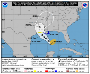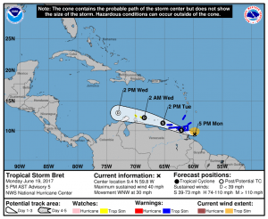
The tropics are very active with two tropical cyclones taking shape within the Atlantic Hurricane Basin: Tropical Storm Bret has formed and Tropical Storm Cindy is on the way, prompting watches to be issued for the US coast.
A pair of ASCAT passes between earlier this afternoon showed that the disturbance over the Gulf of Mexico has an area of tropical-storm-force winds within a large area of deep convection 100 to 150 nautical miles northeast of a broad low center. The ASCAT data and visible satellite imagery show that the center is not well defined, and in fact, multiple low-level swirls are evident in the latest imagery. An Air Force Reserve Hurricane Hunter aircraft is currently investigating the system and will provide more data on its wind structure.
Once this disturbance develops more structure and officially becomes a tropical storm, it will be named Cindy, the third named storm of the 2017 Atlantic Hurricane Season. Even if it approaches the Gulf Coast as a weak tropical storm and never intensifies into a hurricane, it will create many major problems. With copious amounts of moisture to work with, rain will be measured in many inches along the center and to the east of this system; parts of the northeastern Gulf Coast from Louisiana to Florida could see major, flooding rains. This rain-maker will continue to move north and eventually north east, bringing soaking rains further north up the East Coast.
The National Hurricane Center has issued Tropical Storm Warnings and Watches ahead of Cindy’s arrival. A Tropical Storm Warning is in effect from Intracoastal City, Louisiana, to the Mouth of the Pearl River. A Tropical Storm Watch is in effect from west of Intracoastal City to High Island, Texas. A Tropical Storm Warning means that tropical storm conditions are expected somewhere within the warning area, in this case within the next 24 to 36 hours. A Tropical Storm Watch means that tropical storm conditions are possible within the watch area, generally within 48 hours. People in a Watch should make sure their Hurricane Action Plan is in order; people in a Warning should begin to act on that plan.
The National Hurricane Center cautions interests elsewhere along the U.S. Gulf Coast from the central Texas coast to the western Florida Panhandle should monitor the progress of this system.

While Cindy is taking shape over the Gulf, the tropics gave birth to a new storm today: Bret. Bret has maximum sustained winds of 40mph and is racing off to the west at about 30mph. On this track, Bret my travel over the island of Bermuda. Tropical Storm Warnings are now in effect for Trinidad, Tobago, Grenada, and Venezuela from Padernales to Cumana including Isla de Margarita. A Tropical Storm Watch is in effect for Bonaire, Curaco, and Aruba. People there should make sure their Hurricane Action Plans are in order and act on them should warnings be issued.